Hiking the Mount Sanitas Loop: Boulder’s Perfect Urban Escape
Hiking the Mount Sanitas Loop: Boulder’s Perfect Urban Escape
The Mount Sanitas Loop isn’t just a trail; it’s a rite of passage for hikers who crave both challenge and reward. This 3.1-mile circuit, a fusion of the Mount Sanitas Trail, East Ridge Trail, and Sanitas Valley Trail, takes you on a journey through Boulder’s rugged beauty. Minutes from downtown yet worlds away from the bustle, this moderately challenging trek is a love letter to Colorado’s foothills.
From the Mount Sanitas Trailhead, the loop wastes no time getting your blood pumping. The ascent is a stairmaster carved by nature, with steep, rocky switchbacks that lead you higher into the pines. As you climb, glimpses of Boulder peek through the trees, encouraging you upward. The trail demands focus—its uneven terrain and sheer incline keep you grounded in the moment, one step at a time.
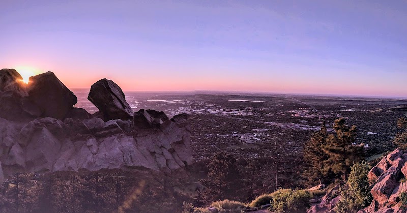
When you reach the East Ridge Trail, the effort pays off. The ridge rewards you with a sweeping panorama of Boulder Valley, the Flatirons standing like sentinels against the sky. Here, the trail levels out just enough to catch your breath. On breezy days, the wind dances across the ridge, carrying whispers of the city below and the promise of more adventure ahead.
The descent via Sanitas Valley Trail is a gentle unwinding. This wide, peaceful path is a stark contrast to the rocky climb, offering smooth terrain and open views of golden grasses and occasional deer. It’s a chance to reflect on the journey, your legs pleasantly tired but your spirit buzzing with accomplishment.
Whether you’re a local or a visitor, the Mount Sanitas Loop is a trail that lingers in your mind long after your boots leave the dirt. It’s not just about the hike—it’s about the connection to the wild beauty that defines Boulder.
Adventure Guide Summary: Mount Sanitas Loop
Trail Overview
- Distance: 3.1 miles (loop)
- Elevation Gain: ~1,300 feet
- Difficulty: Moderate
- Trail Type: Loop (Mount Sanitas Trail, East Ridge Trail, Sanitas Valley Trail)
- Estimated Time: 1.5–3 hours
Highlights and Features
- Trailhead Location: Start at the Centennial Trailhead near 4th Street and Mapleton Avenue. Conveniently close to downtown Boulder, it’s easily accessible by car or foot.
- Terrain: Rocky and steep during the ascent; exposed and breezy on the ridge; smooth and relaxing on the valley descent.
- Seasonal Notes: Spring to fall is ideal for this hike. In winter, wear microspikes for icy sections.
Hiking the Loop
- Mount Sanitas Trail: A challenging climb with sharp switchbacks and rocky footing. Watch your step and enjoy the increasing views as you ascend.
- East Ridge Trail: The ridge offers sweeping vistas and a welcome break from the climb. Perfect for a snack stop or photo op.
- Sanitas Valley Trail: A serene and wide trail leading back to the trailhead. Great for cooling down and soaking in the surrounding foothills.
Helpful Tips
- Footwear: Sturdy hiking boots are essential for navigating rocky terrain.
- Hydration: Carry at least 1–2 liters of water, especially in warmer weather.
- Timing: Arrive early on weekends to avoid crowds and secure parking.
- Wildlife: Deer sightings are common; keep a respectful distance.
Getting There
From downtown Boulder, drive west on Pearl Street, then turn right onto 4th Street. Follow 4th Street to Mapleton Avenue and turn left. The parking area for the trailhead will be on your right.
Local Tip
After the hike, stop by one of Boulder’s many downtown cafes for a coffee or pastry. The post-hike buzz pairs perfectly with the city’s laid-back charm.
Adventure Map
Boulder Info
No GPX info