THE ADVENTURE COLLECTIVE® · Independent discovery and booking for outdoor travel

Ride from Mendoza into the high Andes for a short, high-altitude hike to Laguna de Horcones and a close-up view of Aconcagua’s South Face. Scenic stops at Potrerillos, Uspallata, and Puente del Inca round out a full day that balances road-trip vistas with a rewarding walk.
Ride from Mendoza into the high Andes for a short, high-altitude hike to Laguna de Horcones and a close-up view of Aconcagua’s South Face. Scenic stops at Potrerillos, Uspallata, and Puente del Inca round out a full day that balances road-trip vistas with a rewarding walk.
Dawn loosens its grip on Mendoza as the van rolls west, vineyards giving way to ochre foothills and the river chattering beside Provincial Route 86. The mountains gather quickly here. Past Cacheuta’s stone tunnel and the blue plane of Potrerillos Dam, the Cordón del Plata rises like a stern teacher, its snowfields explaining exactly where the region’s water is born. The road aims higher, threading Andean valleys where the air turns sharp and the sky stretches thin.
Verified experiences and guided adventures in the surrounding area.
Operated by Kahuak · Puente del Inca, Mendoza
Dawn loosens its grip on Mendoza as the van rolls west, vineyards giving way to ochre foothills and the river chattering beside Provincial Route 86. The mountains gather quickly here. Past Cacheuta’s stone tunnel and the blue plane of Potrerillos Dam, the Cordón del Plata rises like a stern teacher, its snowfields explaining exactly where the region’s water is born. The road aims higher, threading Andean valleys where the air turns sharp and the sky stretches thin.
In Uspallata, a green pause in a world of rock, the valley widens—good coffee, a last bathroom break, a pulse of history where muleteers once traded on the old trans-Andean route. A little farther, Puente del Inca appears like a geological dare: a mineral-stained natural bridge arcing over the Río Cuevas. Steam from hot springs whispers along the cliff. The mountains nod you onward.
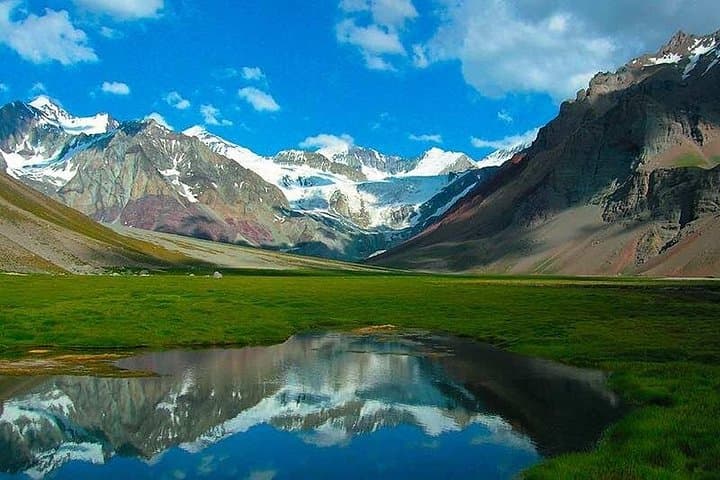
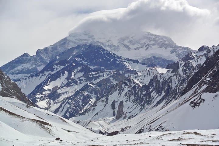
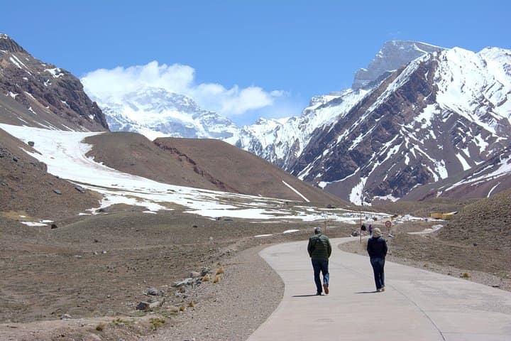
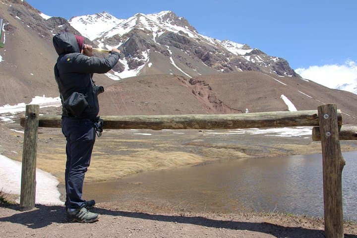
Aconcagua Provincial Park sits at roughly 2,950 meters, where the wind has an opinion and the sun does not forgive. Permits checked, passports shown, boots laced—the Horcones Valley trail begins on a well-marked path. This is a short hike by distance (roughly 3–4 km round-trip with minimal elevation gain), but altitude makes every step count. The trail skirts the Horcones River, which hurries along, urging you to keep pace. Soon the Laguna de Horcones spreads under a bowl of summits, a mirror when calm and a dark eye when wind stirs. On clear days, Aconcagua’s South Face commands the horizon—ice gullies and shadowed walls that have tested alpinists for generations.
Geology does the talking here: uplifted marine sediments, iron-rich springs, and the Andean backbone pushing skyward. Culture follows—Inca routes once threaded this corridor; mountaineers have chased the summit since Matthias Zurbriggen’s first ascent in 1897. Today’s objective is humbler, but no less rewarding: walk, look, breathe, and let altitude remind you who’s in charge.
Expect 8–11 hours door to door from Mendoza, including scenic stops and a hot regional lunch in a mountain parador. The trail itself takes about 1–2 hours at an unhurried pace. Weather shifts fast; summer brings high UV and afternoon gusts, shoulder seasons serve crisp clarity, and winter can close the route with snow and black ice. When conditions align, the park opens a window onto the highest peak in the Americas—a simple walk with outsized views.
Pack water, layers, sunscreen, and Argentine pesos for the park fee (foreigners pay a different rate). Carry your passport. Move slowly, drink often, and let the Andes set the tempo. Out here, the wind pushes, the river prods, and Aconcagua watches—all you have to do is keep moving forward.
The Horcones trail to the lagoon and viewpoint is roughly 3–4 km round-trip with minimal elevation gain, typically taking 1–2 hours at an easy pace.
Yes. A paid entrance ticket is required, checked by park rangers. Bring your passport and Argentine pesos; foreign visitor rates differ.
On clear days, yes—Aconcagua’s South Face and summit are visible from the Horcones viewpoint. Cloud and wind can obscure views, especially in winter.
Route 7 can be affected by snow, black ice, and high winds in winter. The operator may adjust or cancel the itinerary for safety.
The park entrance sits near 2,950 m (9,678 ft). Mild symptoms like shortness of breath or headache are common; move slowly, hydrate, and advise your guide if you feel unwell.
Yes, a hot regional lunch at a mountain parador is included, along with a morning snack. Dietary needs should be communicated in advance.
Kahuak operates guided outdoor trips and adventures with an emphasis on safety, stewardship, and memorable experiences.
Dawn loosens its grip on Mendoza as the van rolls west, vineyards giving way to ochre foothills and the river chattering beside Provincial Route 86. The mountains gather quickly here. Past Cacheuta’s stone tunnel and the blue plane of Potrerillos Dam, the Cordón del Plata rises like a stern teacher, its snowfields explaining exactly where the region’s water is born. The road aims higher, threading Andean valleys where the air turns sharp and the sky stretches thin.
Dawn loosens its grip on Mendoza as the van rolls west, vineyards giving way to ochre foothills and the river chattering beside Provincial Route 86. The mountains gather quickly here. Past Cacheuta’s stone tunnel and the blue plane of Potrerillos Dam, the Cordón del Plata rises like a stern teacher, its snowfields explaining exactly where the region’s water is born. The road aims higher, threading Andean valleys where the air turns sharp and the sky stretches thin.
In Uspallata, a green pause in a world of rock, the valley widens—good coffee, a last bathroom break, a pulse of history where muleteers once traded on the old trans-Andean route. A little farther, Puente del Inca appears like a geological dare: a mineral-stained natural bridge arcing over the Río Cuevas. Steam from hot springs whispers along the cliff. The mountains nod you onward.
Aconcagua Provincial Park sits at roughly 2,950 meters, where the wind has an opinion and the sun does not forgive. Permits checked, passports shown, boots laced—the Horcones Valley trail begins on a well-marked path. This is a short hike by distance (roughly 3–4 km round-trip with minimal elevation gain), but altitude makes every step count. The trail skirts the Horcones River, which hurries along, urging you to keep pace. Soon the Laguna de Horcones spreads under a bowl of summits, a mirror when calm and a dark eye when wind stirs. On clear days, Aconcagua’s South Face commands the horizon—ice gullies and shadowed walls that have tested alpinists for generations.
Geology does the talking here: uplifted marine sediments, iron-rich springs, and the Andean backbone pushing skyward. Culture follows—Inca routes once threaded this corridor; mountaineers have chased the summit since Matthias Zurbriggen’s first ascent in 1897. Today’s objective is humbler, but no less rewarding: walk, look, breathe, and let altitude remind you who’s in charge.
Expect 8–11 hours door to door from Mendoza, including scenic stops and a hot regional lunch in a mountain parador. The trail itself takes about 1–2 hours at an unhurried pace. Weather shifts fast; summer brings high UV and afternoon gusts, shoulder seasons serve crisp clarity, and winter can close the route with snow and black ice. When conditions align, the park opens a window onto the highest peak in the Americas—a simple walk with outsized views.
Pack water, layers, sunscreen, and Argentine pesos for the park fee (foreigners pay a different rate). Carry your passport. Move slowly, drink often, and let the Andes set the tempo. Out here, the wind pushes, the river prods, and Aconcagua watches—all you have to do is keep moving forward.