THE ADVENTURE COLLECTIVE® · Independent discovery and booking for outdoor travel

Circle the Peitlerkofel on a six‑hour guided hike from Würzjoch, where dolomite walls, alpine pastures and chamois-filled ledges create postcard views. This easy‑to‑moderate tour blends geology, Ladin culture and local food stops for a compact, memorable mountain day.
Circle the Peitlerkofel on a six‑hour guided hike from Würzjoch, where dolomite walls, alpine pastures and chamois-filled ledges create postcard views. This easy‑to‑moderate tour blends geology, Ladin culture and local food stops for a compact, memorable mountain day.
You step from an air-conditioned van onto the narrow shoulder of Würzjoch and the noise of the valley falls away. The trail unspools ahead—stone switchbacks, a ribbon of alpine grass, and the Peitlerkofel massif rising like a ruined cathedral of pale rock. Wind writes its own map along the ridges; chamois watch from ledges, unhurried and curious. For six hours you move through that clarity between sky and stone: high pastures, a col at Peitlerscharte (≈2,300 m), and viewpoints that open across the UNESCO Dolomites.
Verified experiences and guided adventures in the surrounding area.
Operated by Georg's Natur-Tage · San Martino in Badia, Trentino-Alto Adige/Südtirol
You step from an air-conditioned van onto the narrow shoulder of Würzjoch and the noise of the valley falls away. The trail unspools ahead—stone switchbacks, a ribbon of alpine grass, and the Peitlerkofel massif rising like a ruined cathedral of pale rock. Wind writes its own map along the ridges; chamois watch from ledges, unhurried and curious. For six hours you move through that clarity between sky and stone: high pastures, a col at Peitlerscharte (≈2,300 m), and viewpoints that open across the UNESCO Dolomites.
Geology here is the story of warm seas turned to vertical cliffs. The Dolomites are ancient carbonate reefs uplifted and sculpted into spires, walls, and broad amphitheaters. Peitlerkofel—Sass de Putia in Ladin—stands distinct for its compact towers and knife-edged ridges. Culturally the pass marks a meeting zone: German-speaking valleys to the north and Ladin-speaking communities to the east. Guides Georg and Patrick weave local memory into the walk—pastoral trails, wartime routes carved into rock, and the stubborn persistence of mountain farms that still move cattle each summer to high alpine meadows.
The loop around Peitlerkofel is straightforward but honest: expect roughly 10–14 km with 600–800 m of ascent depending on route choices. Terrain shifts from packed soil to rocky steps and short scree fields near the col—good boots and sure footing make the day faster and safer. Wildlife encounters are common; golden eagles patrol thermals and chamois pick their way on cliff bands. On request, the hike can finish with a South Tyrolean snack—speck, mountain cheese and fresh bread—served at a rifugio for a grounded, local finish.
Practical guide: start early to catch low light on the east faces and to avoid afternoon storms that can roll in fast. Bring 1.5–2 liters of water, a windproof shell, and layered clothing—exposure on the Peitlerscharte is real even in summer. If you suffer from vertigo, ask the guide about alternative lower routes; there are gentle variants that still deliver classic views.
Why this circuit: it’s compact enough for a single, memorable day yet rich with geological drama and linguistic crossroads. The guides know the photo hotspots and wildlife habits, turning a good hike into a well-paced mountain experience.
If you go: respect trail signs, carry out any waste, and leave early in the season if you want lingering snowfields; late summer offers the most stable conditions. Above all, move at the mountain’s rhythm—there’s a reason these peaks have shaped the people who live below them.
The typical circuit is about 10–14 km with roughly 600–800 m of elevation gain; guides can shorten the route on request.
Yes for older children used to walking; everyone should have decent shoes and a moderate fitness level—guides can adjust pace and route.
Guides typically speak German and Italian; many also speak English and will explain Ladin culture and local mountain history during the tour.
Yes—chamois and a variety of alpine birds are commonly seen, especially in the quieter morning hours.
The operator may cancel for storms or unsafe conditions (full refund if canceled more than 24 hours prior); guides will reroute or shorten the hike if conditions warrant.
Yes—a pickup from Bolzano is possible for an extra fee (noted by the supplier); hotel pickup within the region is often available.
Georg's Natur-Tage operates guided outdoor trips and adventures with an emphasis on safety, stewardship, and memorable experiences.


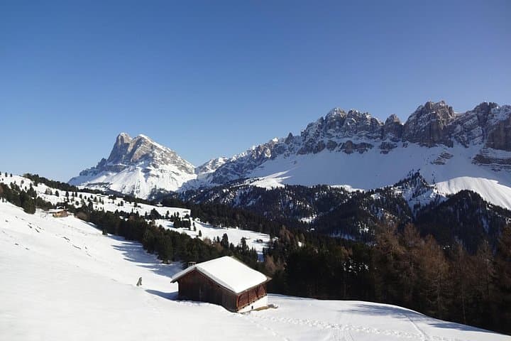
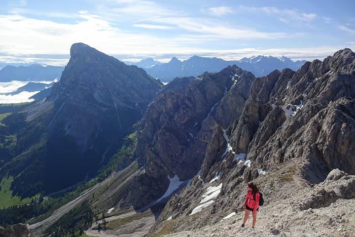
You step from an air-conditioned van onto the narrow shoulder of Würzjoch and the noise of the valley falls away. The trail unspools ahead—stone switchbacks, a ribbon of alpine grass, and the Peitlerkofel massif rising like a ruined cathedral of pale rock. Wind writes its own map along the ridges; chamois watch from ledges, unhurried and curious. For six hours you move through that clarity between sky and stone: high pastures, a col at Peitlerscharte (≈2,300 m), and viewpoints that open across the UNESCO Dolomites.
You step from an air-conditioned van onto the narrow shoulder of Würzjoch and the noise of the valley falls away. The trail unspools ahead—stone switchbacks, a ribbon of alpine grass, and the Peitlerkofel massif rising like a ruined cathedral of pale rock. Wind writes its own map along the ridges; chamois watch from ledges, unhurried and curious. For six hours you move through that clarity between sky and stone: high pastures, a col at Peitlerscharte (≈2,300 m), and viewpoints that open across the UNESCO Dolomites.
Geology here is the story of warm seas turned to vertical cliffs. The Dolomites are ancient carbonate reefs uplifted and sculpted into spires, walls, and broad amphitheaters. Peitlerkofel—Sass de Putia in Ladin—stands distinct for its compact towers and knife-edged ridges. Culturally the pass marks a meeting zone: German-speaking valleys to the north and Ladin-speaking communities to the east. Guides Georg and Patrick weave local memory into the walk—pastoral trails, wartime routes carved into rock, and the stubborn persistence of mountain farms that still move cattle each summer to high alpine meadows.
The loop around Peitlerkofel is straightforward but honest: expect roughly 10–14 km with 600–800 m of ascent depending on route choices. Terrain shifts from packed soil to rocky steps and short scree fields near the col—good boots and sure footing make the day faster and safer. Wildlife encounters are common; golden eagles patrol thermals and chamois pick their way on cliff bands. On request, the hike can finish with a South Tyrolean snack—speck, mountain cheese and fresh bread—served at a rifugio for a grounded, local finish.
Practical guide: start early to catch low light on the east faces and to avoid afternoon storms that can roll in fast. Bring 1.5–2 liters of water, a windproof shell, and layered clothing—exposure on the Peitlerscharte is real even in summer. If you suffer from vertigo, ask the guide about alternative lower routes; there are gentle variants that still deliver classic views.
Why this circuit: it’s compact enough for a single, memorable day yet rich with geological drama and linguistic crossroads. The guides know the photo hotspots and wildlife habits, turning a good hike into a well-paced mountain experience.
If you go: respect trail signs, carry out any waste, and leave early in the season if you want lingering snowfields; late summer offers the most stable conditions. Above all, move at the mountain’s rhythm—there’s a reason these peaks have shaped the people who live below them.