THE ADVENTURE COLLECTIVE® · Independent discovery and booking for outdoor travel

A compact three-day loop through Ha Giang’s Dong Van Karst Plateau with scenic drives, village walks and the dramatic Ma Pi Leng Pass. Expect long road time balanced by culturally rich stops and short hikes on varied terrain.
A compact three-day loop through Ha Giang’s Dong Van Karst Plateau with scenic drives, village walks and the dramatic Ma Pi Leng Pass. Expect long road time balanced by culturally rich stops and short hikes on varied terrain.
High on the road out of Hanoi the air changes: rice terraces shrink, karst towers grow, and a narrow ribbon of asphalt threads the northern ridgelines. On this three-day loop through Ha Giang province travelers trade city noise for long mountain drives, short village hikes and sunrise over rivers cut deep into limestone.
Verified experiences and guided adventures in the surrounding area.
Operated by Conical Travel · Ha Giang, Ha Giang Province
High on the road out of Hanoi the air changes: rice terraces shrink, karst towers grow, and a narrow ribbon of asphalt threads the northern ridgelines. On this three-day loop through Ha Giang province travelers trade city noise for long mountain drives, short village hikes and sunrise over rivers cut deep into limestone.
The route travels the Dong Van Karst Plateau Global Geopark, a landscape shaped by ancient coral reefs lifted by tectonic action and sculpted by monsoon rains. Scattered hamlets are largely Hmong and Yao communities whose traditions and house styles reflect centuries of upland life. Key landmarks include Quan Ba’s twin peaks, the Dong Van old quarter and the vertiginous Ma Pi Leng Pass where the Nho Que River chisels the valley below.
Expect long transfers—many driving segments of 3–5 hours—punctuated by 1–3 hour walks on mixed dirt and paved village trails. Elevations on the plateau run roughly 900–1,300 m; Ma Pi Leng reaches steep roadside viewpoints rather than alpine summits. Terrain is rocky, can be windy, and trails often follow village lanes or river terraces.
Practical side: travel is by A/C car with a local English-speaking guide; homestays or simple hotels provide local meals. Bring a layered system for cool mornings and warm afternoons, sturdy trail shoes for village paths and riverbank steps, and a daypack with water and rain protection. Morning markets, short cultural walks and viewpoint stops reward early starts—pace yourself and leave space for unplanned photo stops.
Walks are short to moderate (1–3 hours) on village lanes and terrace paths; they are not technical but can be uneven—good footwear is enough.
Nights are in local homestays or simple 3-star hotels in Yen Minh and Quan Ba with meals as described in the itinerary.
Elevations are generally 900–1,300 m with some roadside viewpoints higher; altitude effects are minimal for most travelers.
The tour includes sightseeing tickets and travel permits where required; travelers should carry ID documents as requested at booking.
Conical Travel operates guided outdoor trips and adventures with an emphasis on safety, stewardship, and memorable experiences.
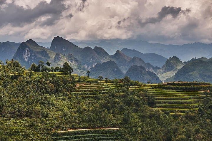


High on the road out of Hanoi the air changes: rice terraces shrink, karst towers grow, and a narrow ribbon of asphalt threads the northern ridgelines. On this three-day loop through Ha Giang province travelers trade city noise for long mountain drives, short village hikes and sunrise over rivers cut deep into limestone.
High on the road out of Hanoi the air changes: rice terraces shrink, karst towers grow, and a narrow ribbon of asphalt threads the northern ridgelines. On this three-day loop through Ha Giang province travelers trade city noise for long mountain drives, short village hikes and sunrise over rivers cut deep into limestone.
The route travels the Dong Van Karst Plateau Global Geopark, a landscape shaped by ancient coral reefs lifted by tectonic action and sculpted by monsoon rains. Scattered hamlets are largely Hmong and Yao communities whose traditions and house styles reflect centuries of upland life. Key landmarks include Quan Ba’s twin peaks, the Dong Van old quarter and the vertiginous Ma Pi Leng Pass where the Nho Que River chisels the valley below.
Expect long transfers—many driving segments of 3–5 hours—punctuated by 1–3 hour walks on mixed dirt and paved village trails. Elevations on the plateau run roughly 900–1,300 m; Ma Pi Leng reaches steep roadside viewpoints rather than alpine summits. Terrain is rocky, can be windy, and trails often follow village lanes or river terraces.
Practical side: travel is by A/C car with a local English-speaking guide; homestays or simple hotels provide local meals. Bring a layered system for cool mornings and warm afternoons, sturdy trail shoes for village paths and riverbank steps, and a daypack with water and rain protection. Morning markets, short cultural walks and viewpoint stops reward early starts—pace yourself and leave space for unplanned photo stops.