THE ADVENTURE COLLECTIVE® · Independent discovery and booking for outdoor travel

Three days of ridge-top passes, river canyons and homestays on Vietnam’s Ha Giang Loop. Ride Ma Pi Leng, boat the Nho Que and hike to Tham Luong waterfall with local guides and village hospitality.
Three days of ridge-top passes, river canyons and homestays on Vietnam’s Ha Giang Loop. Ride Ma Pi Leng, boat the Nho Que and hike to Tham Luong waterfall with local guides and village hospitality.
A cold dawn in Ha Giang loosens the fog like a curtain and the road ahead tightens into switchbacks that climb through limestone ribs. On this three-day Ha Giang loop you move between high, wind-swept passes and narrow river canyons: the first day's 80 km traces the historic Cu Vuong route, the second carves toward Ma Pi Leng's 1,200 m ridge above the Nho Que, and the third trades roads for a 5–6 km hike to Tham Luong waterfall.
Verified experiences and guided adventures in the surrounding area.
Operated by Victory Era Travel · Ha Giang, Ha Giang Province
A cold dawn in Ha Giang loosens the fog like a curtain and the road ahead tightens into switchbacks that climb through limestone ribs. On this three-day Ha Giang loop you move between high, wind-swept passes and narrow river canyons: the first day's 80 km traces the historic Cu Vuong route, the second carves toward Ma Pi Leng's 1,200 m ridge above the Nho Que, and the third trades roads for a 5–6 km hike to Tham Luong waterfall.
The region is geologically young — steep karst towers and folded shale that rivers have sliced into sheer cliffs. Culturally the loop threads Hmong and Tay villages, weekly markets in Dong Van where traditional dress and hemp textiles are still made by hand, and scattered French-era watchtowers that mark a contested colonial past.
Expect mixed surfaces: paved provincial roads, gravel shoulders, and short goat tracks by homestays. Elevation swings make temperatures variable: mornings and passes can be chilly while valley bottoms feel tropical by noon. The Nho Que river dares you from below; a short boat trip on its emerald water gives perspective on the canyon depth.
Practical guidance: ride with an experienced easy rider if you’re not confident — helmets are mandatory. Pack a layering system, waterproof shell, and sturdy ankle-support shoes for village walks and waterfall hikes. Bring cash for markets and modest homestays; phone signal is patchy so download maps offline. Time your trip outside the core monsoon window (June–September) for clearer roads and drier trails.
No — the tour provides experienced easy riders if you prefer to be a passenger; self-ride is optional but riders should be confident on mountain roads.
Most walks are short to moderate (around 5–6 km, uneven terrain and elevation change); basic fitness and good footwear are sufficient.
The tour includes an English-speaking guide; local homestay hosts may speak minimal English but are welcoming.
Stick to bottled or boiled water; homestays typically provide safe drinking water and you should avoid unfiltered local streams.
Victory Era Travel operates guided outdoor trips and adventures with an emphasis on safety, stewardship, and memorable experiences.
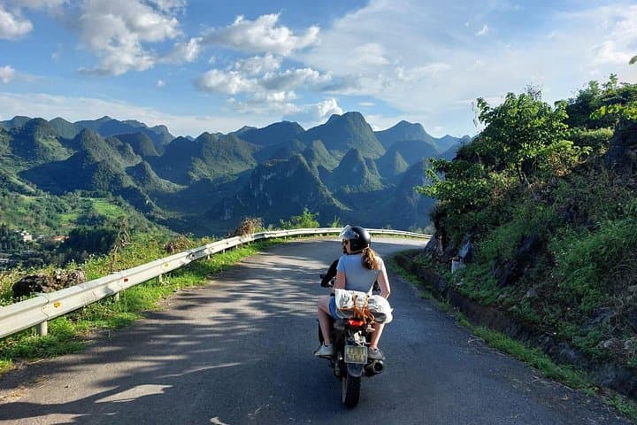


A cold dawn in Ha Giang loosens the fog like a curtain and the road ahead tightens into switchbacks that climb through limestone ribs. On this three-day Ha Giang loop you move between high, wind-swept passes and narrow river canyons: the first day's 80 km traces the historic Cu Vuong route, the second carves toward Ma Pi Leng's 1,200 m ridge above the Nho Que, and the third trades roads for a 5–6 km hike to Tham Luong waterfall.
A cold dawn in Ha Giang loosens the fog like a curtain and the road ahead tightens into switchbacks that climb through limestone ribs. On this three-day Ha Giang loop you move between high, wind-swept passes and narrow river canyons: the first day's 80 km traces the historic Cu Vuong route, the second carves toward Ma Pi Leng's 1,200 m ridge above the Nho Que, and the third trades roads for a 5–6 km hike to Tham Luong waterfall.
The region is geologically young — steep karst towers and folded shale that rivers have sliced into sheer cliffs. Culturally the loop threads Hmong and Tay villages, weekly markets in Dong Van where traditional dress and hemp textiles are still made by hand, and scattered French-era watchtowers that mark a contested colonial past.
Expect mixed surfaces: paved provincial roads, gravel shoulders, and short goat tracks by homestays. Elevation swings make temperatures variable: mornings and passes can be chilly while valley bottoms feel tropical by noon. The Nho Que river dares you from below; a short boat trip on its emerald water gives perspective on the canyon depth.
Practical guidance: ride with an experienced easy rider if you’re not confident — helmets are mandatory. Pack a layering system, waterproof shell, and sturdy ankle-support shoes for village walks and waterfall hikes. Bring cash for markets and modest homestays; phone signal is patchy so download maps offline. Time your trip outside the core monsoon window (June–September) for clearer roads and drier trails.