THE ADVENTURE COLLECTIVE® · Independent discovery and booking for outdoor travel

A four-day circuit through Vietnam’s Ha Giang Plateau, this loop combines mountain passes, remote villages and homestays. Ride Ma Pi Leng, float the Nho Que canyon and sleep in traditional houses for an intimate picture of northern highland life.
A four-day circuit through Vietnam’s Ha Giang Plateau, this loop combines mountain passes, remote villages and homestays. Ride Ma Pi Leng, float the Nho Que canyon and sleep in traditional houses for an intimate picture of northern highland life.
Clouds unspool along hairpin turns as the sleeper bus drops you into northeastern Vietnam’s limestone highlands. On day one the road unfurls—six hours from Hanoi to Ha Giang—then the real loop begins: narrow passes, terrace-cut valleys and small towns where motorbikes thread between stalls and dogs sleeping on stone thresholds.
Verified experiences and guided adventures in the surrounding area.
Operated by Local Tours ASIA · Ha Giang, Ha Giang Province
Clouds unspool along hairpin turns as the sleeper bus drops you into northeastern Vietnam’s limestone highlands. On day one the road unfurls—six hours from Hanoi to Ha Giang—then the real loop begins: narrow passes, terrace-cut valleys and small towns where motorbikes thread between stalls and dogs sleeping on stone thresholds.
This route traces the Ha Giang Karst Plateau Geopark, a landscape of weathered limestone, sharp escarpments and table-like plateaus carved over millions of years. Human history is layered on top: H’Mong and Tay villages cling to ridgelines, the Vuong family palace recalls local chieftains, and weekend markets remain social centers where brocade and corn wine trade hands.
Expect the technical high point at Ma Pi Leng Pass (near 2,000 m), where the road clings to the mountain and the Nho Que River cuts a deep gorge below. Distances on the loop total roughly 300–350 km of driving across mixed paved and rough asphalt; many viewpoints require short walks on rocky ground.
Practical guidance: pack warm layers for morning passes, a rain shell for sudden squalls, and sturdy shoes for village walks. If you opt for motorbike segments, choose an experienced rider or Easy Rider option; helmets are provided but bring sunglasses and a reusable water bottle. Best windows for clearer skies are spring (March–May) and autumn (September–November). Plan for early starts, variable road surfaces, and the generosity of homestay hosts—this loop rewards patience with expansive views and genuine cultural encounters.
The itinerary runs four days and three nights, covering approximately 300–350 km with multiple stops at viewpoints, villages and the Ma Pi Leng Pass.
No—there’s an Easy Rider/motorbike-with-driver option; if you do ride yourself, basic experience on winding mountain roads is recommended.
Homestays vary but are generally clean and simple with shared facilities; the tour includes a mix of hotels and local homestays for cultural immersion.
Spring (March–May) and autumn (September–November) offer the most stable weather and best visibility for views.
Local Tours ASIA operates guided outdoor trips and adventures with an emphasis on safety, stewardship, and memorable experiences.

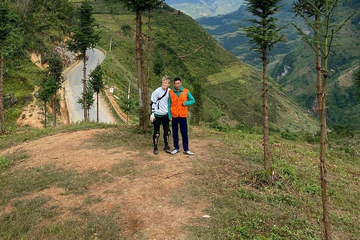


Clouds unspool along hairpin turns as the sleeper bus drops you into northeastern Vietnam’s limestone highlands. On day one the road unfurls—six hours from Hanoi to Ha Giang—then the real loop begins: narrow passes, terrace-cut valleys and small towns where motorbikes thread between stalls and dogs sleeping on stone thresholds.
Clouds unspool along hairpin turns as the sleeper bus drops you into northeastern Vietnam’s limestone highlands. On day one the road unfurls—six hours from Hanoi to Ha Giang—then the real loop begins: narrow passes, terrace-cut valleys and small towns where motorbikes thread between stalls and dogs sleeping on stone thresholds.
This route traces the Ha Giang Karst Plateau Geopark, a landscape of weathered limestone, sharp escarpments and table-like plateaus carved over millions of years. Human history is layered on top: H’Mong and Tay villages cling to ridgelines, the Vuong family palace recalls local chieftains, and weekend markets remain social centers where brocade and corn wine trade hands.
Expect the technical high point at Ma Pi Leng Pass (near 2,000 m), where the road clings to the mountain and the Nho Que River cuts a deep gorge below. Distances on the loop total roughly 300–350 km of driving across mixed paved and rough asphalt; many viewpoints require short walks on rocky ground.
Practical guidance: pack warm layers for morning passes, a rain shell for sudden squalls, and sturdy shoes for village walks. If you opt for motorbike segments, choose an experienced rider or Easy Rider option; helmets are provided but bring sunglasses and a reusable water bottle. Best windows for clearer skies are spring (March–May) and autumn (September–November). Plan for early starts, variable road surfaces, and the generosity of homestay hosts—this loop rewards patience with expansive views and genuine cultural encounters.