THE ADVENTURE COLLECTIVE® · Independent discovery and booking for outdoor travel

Four days of high passes, karst plateaus and market-side culture, driven in a private car from Sapa through Ha Giang’s most dramatic highlights. Expect long drives, brief walks, and immersive visits to Hmong villages and the Ma Pi Leng ridge.
Four days of high passes, karst plateaus and market-side culture, driven in a private car from Sapa through Ha Giang’s most dramatic highlights. Expect long drives, brief walks, and immersive visits to Hmong villages and the Ma Pi Leng ridge.
Early light rides the ridgelines as a private car peels away from Sapa toward Vietnam’s northernmost spine. The road climbs and folds, villages appearing like pages of a lived-in map — terraced fields, slate-roofed houses, and the slow, patient Nho Que River carving the valley below. Travelers spend four days moving through Dong Van Karst Plateau Geopark, pausing at high passes and market towns where languages change as fast as the scenery.
Verified experiences and guided adventures in the surrounding area.
Operated by Authentuc PU LUONG · Ha Giang, Ha Giang
Early light rides the ridgelines as a private car peels away from Sapa toward Vietnam’s northernmost spine. The road climbs and folds, villages appearing like pages of a lived-in map — terraced fields, slate-roofed houses, and the slow, patient Nho Que River carving the valley below. Travelers spend four days moving through Dong Van Karst Plateau Geopark, pausing at high passes and market towns where languages change as fast as the scenery.
Geologically the region is a limestone plateau shaped by millennia of uplift and river erosion; the result is the jagged karst skyline and deep, narrow valleys that define the Ha Giang loop. Historically the area has been a borderland of ethnic diversity — Hmong, Tay, Lo Lo, and Yao communities — each keeping distinct textiles, houses, and foodways. Dong Van’s old quarter and the Vuong (Hmong King) Palace speak to local authority structures from the early 20th century, while roadside markets preserve barter rhythms older than asphalt.
On the third day the Ma Pi Leng Pass offers vertiginous viewpoints over the Nho Que; expect wind that presses at the edge and light that changes fast. Cultural encounters are frequent — respectful photos and small purchases support homestays and artisans.
Practical guidance: pack layers for cold mornings and warm afternoons, bring sturdy shoes for short walks around Lung Cam and Ma Pi Leng, and keep water handy during long drives. Roads are narrow and winding; motion sensitivity and slow travel times are normal. A private car tour concentrates highlights into a short window — plan extra days if you want deeper treks or more market time.
Expect several hours in the car each day between stops; the loop involves long, winding stretches so travel times are longer than straight-line distances.
Homestays vary from basic to modestly equipped; most provide hot meals, simple bedding, and a chance to experience local life rather than hotel amenities.
The tour is suitable for many ages, but those with mobility or cardiovascular issues should consider the long drives and uneven surfaces; consult the operator for private adjustments.
Foreign visitors need a valid Vietnam visa; travel permits for Ha Giang are typically handled by the tour operator and included in the itinerary when required.
Authentuc PU LUONG operates guided outdoor trips and adventures with an emphasis on safety, stewardship, and memorable experiences.

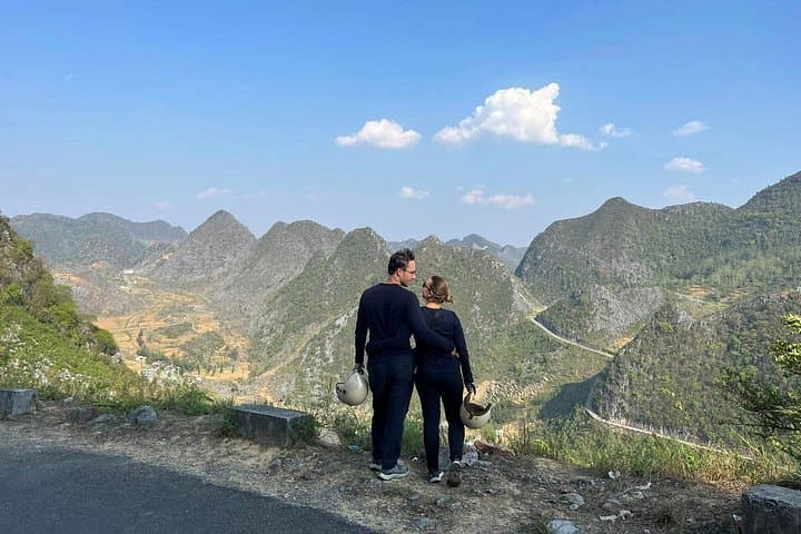


Early light rides the ridgelines as a private car peels away from Sapa toward Vietnam’s northernmost spine. The road climbs and folds, villages appearing like pages of a lived-in map — terraced fields, slate-roofed houses, and the slow, patient Nho Que River carving the valley below. Travelers spend four days moving through Dong Van Karst Plateau Geopark, pausing at high passes and market towns where languages change as fast as the scenery.
Early light rides the ridgelines as a private car peels away from Sapa toward Vietnam’s northernmost spine. The road climbs and folds, villages appearing like pages of a lived-in map — terraced fields, slate-roofed houses, and the slow, patient Nho Que River carving the valley below. Travelers spend four days moving through Dong Van Karst Plateau Geopark, pausing at high passes and market towns where languages change as fast as the scenery.
Geologically the region is a limestone plateau shaped by millennia of uplift and river erosion; the result is the jagged karst skyline and deep, narrow valleys that define the Ha Giang loop. Historically the area has been a borderland of ethnic diversity — Hmong, Tay, Lo Lo, and Yao communities — each keeping distinct textiles, houses, and foodways. Dong Van’s old quarter and the Vuong (Hmong King) Palace speak to local authority structures from the early 20th century, while roadside markets preserve barter rhythms older than asphalt.
On the third day the Ma Pi Leng Pass offers vertiginous viewpoints over the Nho Que; expect wind that presses at the edge and light that changes fast. Cultural encounters are frequent — respectful photos and small purchases support homestays and artisans.
Practical guidance: pack layers for cold mornings and warm afternoons, bring sturdy shoes for short walks around Lung Cam and Ma Pi Leng, and keep water handy during long drives. Roads are narrow and winding; motion sensitivity and slow travel times are normal. A private car tour concentrates highlights into a short window — plan extra days if you want deeper treks or more market time.