THE ADVENTURE COLLECTIVE® · Independent discovery and booking for outdoor travel

A full-day, 21 km hike to Hajla’s 2403 m summit crosses meadows and rocky ridgelines that fall on both Kosovo and Montenegro. Expect long hiking hours, fast weather shifts, and summit views into two countries — best attempted with a local guide.
A full-day, 21 km hike to Hajla’s 2403 m summit crosses meadows and rocky ridgelines that fall on both Kosovo and Montenegro. Expect long hiking hours, fast weather shifts, and summit views into two countries — best attempted with a local guide.
You step out of the van on a sharp morning and the ridge of Hajla looms: a raw line of rock and alpine grass that divides two countries. Wind threads through the meadows and the trail climbs steady from Shtupeqi i Madh, opening into wide views where stone ridgelines slice into the sky and villages sit like small promises far below.
Verified experiences and guided adventures in the surrounding area.
Operated by Top Balkan Tours · Peja, Pejë District
You step out of the van on a sharp morning and the ridge of Hajla looms: a raw line of rock and alpine grass that divides two countries. Wind threads through the meadows and the trail climbs steady from Shtupeqi i Madh, opening into wide views where stone ridgelines slice into the sky and villages sit like small promises far below.
This route is part of the Peaks of the Balkans and the Via Dinarica network, a corridor forged by glacial sculpting and karst limestone that gives Hajla its steep faces and patchwork scree. The mountain has long been a grazing ground for highland shepherds; cairns and rustic animal paths still mark human use across the slopes.
Expect an eight-hour day covering roughly 21 km with about +603 m and -603 m of elevation change — endurance more than technical climbing. Trails cross alpine meadows, rocky switchbacks and exposed ridgelines; weather can change fast and the summit sits astride the Kosovo–Montenegro border, offering simultaneous views into both countries.
Practical notes: go with a local guide if possible — they know tricky route choices and informal border etiquette — and carry ID if you plan to stand on the high point. Start early to avoid afternoon wind and clouds, bring layered clothing and sturdy boots for limestone scree, and pack enough water and snacks for a long day. Leave no trace: grazing is active in summer, and staying on durable surfaces protects fragile alpine plants. On a clear day, Hajla delivers a compact, memorable high-mountain experience: raw, open, and unmistakably Balkan.
The route is about 21 km and typically takes around 8 hours with ±603 m elevation; it’s long and demanding rather than technically difficult.
A local guide is strongly recommended — trails can be indistinct in places, weather changes quickly, and guides know route variants and local customs at the border.
Late spring through early autumn offers the most stable conditions; snow can linger into spring and winter requires mountaineering experience and gear.
The summit lies on the Kosovo–Montenegro border; hikers should carry ID and verify any crossing rules with the operator or guide before starting.
Top Balkan Tours operates guided outdoor trips and adventures with an emphasis on safety, stewardship, and memorable experiences.
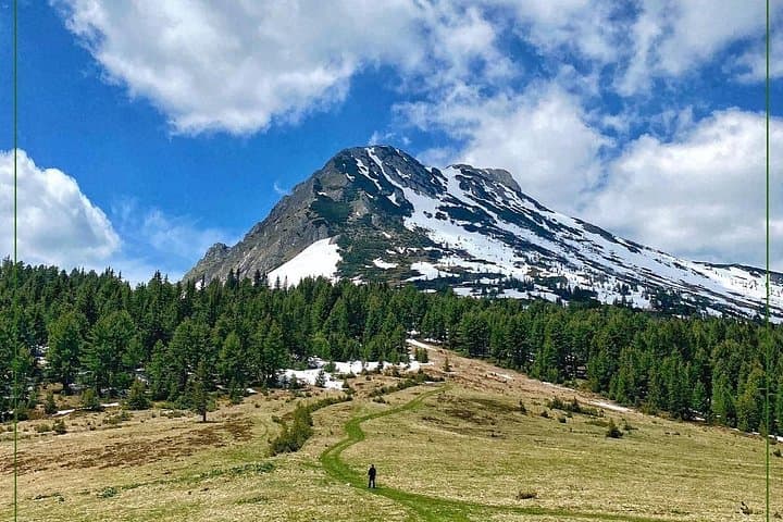


You step out of the van on a sharp morning and the ridge of Hajla looms: a raw line of rock and alpine grass that divides two countries. Wind threads through the meadows and the trail climbs steady from Shtupeqi i Madh, opening into wide views where stone ridgelines slice into the sky and villages sit like small promises far below.
You step out of the van on a sharp morning and the ridge of Hajla looms: a raw line of rock and alpine grass that divides two countries. Wind threads through the meadows and the trail climbs steady from Shtupeqi i Madh, opening into wide views where stone ridgelines slice into the sky and villages sit like small promises far below.
This route is part of the Peaks of the Balkans and the Via Dinarica network, a corridor forged by glacial sculpting and karst limestone that gives Hajla its steep faces and patchwork scree. The mountain has long been a grazing ground for highland shepherds; cairns and rustic animal paths still mark human use across the slopes.
Expect an eight-hour day covering roughly 21 km with about +603 m and -603 m of elevation change — endurance more than technical climbing. Trails cross alpine meadows, rocky switchbacks and exposed ridgelines; weather can change fast and the summit sits astride the Kosovo–Montenegro border, offering simultaneous views into both countries.
Practical notes: go with a local guide if possible — they know tricky route choices and informal border etiquette — and carry ID if you plan to stand on the high point. Start early to avoid afternoon wind and clouds, bring layered clothing and sturdy boots for limestone scree, and pack enough water and snacks for a long day. Leave no trace: grazing is active in summer, and staying on durable surfaces protects fragile alpine plants. On a clear day, Hajla delivers a compact, memorable high-mountain experience: raw, open, and unmistakably Balkan.