THE ADVENTURE COLLECTIVE® · Independent discovery and booking for outdoor travel

Rise above Lysefjord on a helicopter flight that frames Preikestolen — Pulpit Rock — in dramatic, bird’s-eye detail. This six-hour experience combines a scenic transfer from Stavanger with multiple aerial passes for unbeatable views and photo opportunities.
Rise above Lysefjord on a helicopter flight that frames Preikestolen — Pulpit Rock — in dramatic, bird’s-eye detail. This six-hour experience combines a scenic transfer from Stavanger with multiple aerial passes for unbeatable views and photo opportunities.
The rotor thuds low and steady as the helicopter lifts from a Ryfylke heliport, the coast shrinking into a puzzle of fjords and islands. Below, the Lysefjord cuts a razor into the Norwegian mainland; its waters glitter like a dark mirror, daring you to look down. Within minutes the famous square of Preikestolen — Pulpit Rock — appears, a pale plate perched 604 meters above the fjord, its sheer face falling away like the edge of the world.
Verified experiences and guided adventures in the surrounding area.
Operated by Activity Norway · Stavanger, Rogaland
The rotor thuds low and steady as the helicopter lifts from a Ryfylke heliport, the coast shrinking into a puzzle of fjords and islands. Below, the Lysefjord cuts a razor into the Norwegian mainland; its waters glitter like a dark mirror, daring you to look down. Within minutes the famous square of Preikestolen — Pulpit Rock — appears, a pale plate perched 604 meters above the fjord, its sheer face falling away like the edge of the world.
This is not a hike; it’s perspective. The flight threads steep mountain walls, elevated plateaus and coastal towns — Stavanger and Sandnes tucked against the sea — then banks over glaciers’ scars and the hard, exfoliated granite that defines the region. Geologically, Pulpit Rock is the product of the last Ice Age: glaciers scoured the fjord, pryed loose vertical joints in the rock and left the cliff’s dramatic flat top. Culturally, the Lysefjord corridor has been a working landscape for centuries — fishing, small farms and, more recently, industries tied to Stavanger’s oil era — all visible in the checkerboard beneath the rotor.
The tour you’ll take here emphasizes cinematic sightlines. Pilots circle to give passengers multiple angles: the fjord’s narrow throat, waterfalls spilling down black cliffs, and the impossible tabletop of Preikestolen itself. On clear days sunlight stripes the fjord; under cloud, the cliffs take on a brooding, almost tactile quality. Photographers get a rare close-up of faces of rock usually seen from a distance, and you may even spot groups of hikers as colored specks on the plateau.
Practicalities matter: the full experience includes a road transfer from Stavanger, Sandnes or Haugesund to the Ryfylke base — roughly a two-hour drive across ferries and bridges — so plan for a half- to full-day window. Weather drives decisions; flights cancel in fog or high winds, so build flexibility into your itinerary. Mobility needs are accommodated, and the activity is suitable for a wide range of fitness levels since there’s no landing on the cliff.
Bring a windproof layer, secure your camera gear, and expect brief, intense bursts of photography between safety briefings. If you’re prone to motion sickness, take precautions; the view is worth it, but comfort keeps the trip enjoyable. Book mornings or late-afternoon slots for lower sun angles and fewer vessels below.
For travelers who want to pair this with a hike, Preikestolen’s trail is a separate, classic 4–5 hour round trip. From the air, however, you get the cliff in context: the fjord daring you to explore it, the mountains pushing the horizon into an uncompromising frame — and a reminder that some places are best seen from above before you choose how you’ll meet them on the ground.
No — this sightseeing flight performs aerial passes for close-up views and photography, but it does not land on the cliff.
The advertised duration is about six hours door-to-door, including road transfers to the heliport from Stavanger, Sandnes or Haugesund.
Flights are canceled in fog, heavy rain or strong winds; operators generally offer refunds or rebooking if the flight is called off for safety.
The operator lists wheelchair accessibility for transfers and facilities; confirm specific boarding assistance and any personal needs when booking.
Booking questions request passenger weight and ages; certain limits may apply for balance and safety—disclose accurate weights at booking.
Yes — many travelers pair the flight with an independent hike, but note the hike is separate and typically takes 4–5 hours round trip on rough, rocky terrain.
Activity Norway operates guided outdoor trips and adventures with an emphasis on safety, stewardship, and memorable experiences.
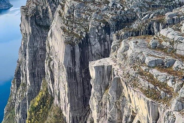
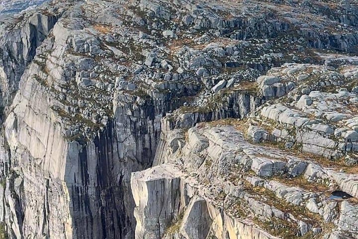


The rotor thuds low and steady as the helicopter lifts from a Ryfylke heliport, the coast shrinking into a puzzle of fjords and islands. Below, the Lysefjord cuts a razor into the Norwegian mainland; its waters glitter like a dark mirror, daring you to look down. Within minutes the famous square of Preikestolen — Pulpit Rock — appears, a pale plate perched 604 meters above the fjord, its sheer face falling away like the edge of the world.
The rotor thuds low and steady as the helicopter lifts from a Ryfylke heliport, the coast shrinking into a puzzle of fjords and islands. Below, the Lysefjord cuts a razor into the Norwegian mainland; its waters glitter like a dark mirror, daring you to look down. Within minutes the famous square of Preikestolen — Pulpit Rock — appears, a pale plate perched 604 meters above the fjord, its sheer face falling away like the edge of the world.
This is not a hike; it’s perspective. The flight threads steep mountain walls, elevated plateaus and coastal towns — Stavanger and Sandnes tucked against the sea — then banks over glaciers’ scars and the hard, exfoliated granite that defines the region. Geologically, Pulpit Rock is the product of the last Ice Age: glaciers scoured the fjord, pryed loose vertical joints in the rock and left the cliff’s dramatic flat top. Culturally, the Lysefjord corridor has been a working landscape for centuries — fishing, small farms and, more recently, industries tied to Stavanger’s oil era — all visible in the checkerboard beneath the rotor.
The tour you’ll take here emphasizes cinematic sightlines. Pilots circle to give passengers multiple angles: the fjord’s narrow throat, waterfalls spilling down black cliffs, and the impossible tabletop of Preikestolen itself. On clear days sunlight stripes the fjord; under cloud, the cliffs take on a brooding, almost tactile quality. Photographers get a rare close-up of faces of rock usually seen from a distance, and you may even spot groups of hikers as colored specks on the plateau.
Practicalities matter: the full experience includes a road transfer from Stavanger, Sandnes or Haugesund to the Ryfylke base — roughly a two-hour drive across ferries and bridges — so plan for a half- to full-day window. Weather drives decisions; flights cancel in fog or high winds, so build flexibility into your itinerary. Mobility needs are accommodated, and the activity is suitable for a wide range of fitness levels since there’s no landing on the cliff.
Bring a windproof layer, secure your camera gear, and expect brief, intense bursts of photography between safety briefings. If you’re prone to motion sickness, take precautions; the view is worth it, but comfort keeps the trip enjoyable. Book mornings or late-afternoon slots for lower sun angles and fewer vessels below.
For travelers who want to pair this with a hike, Preikestolen’s trail is a separate, classic 4–5 hour round trip. From the air, however, you get the cliff in context: the fjord daring you to explore it, the mountains pushing the horizon into an uncompromising frame — and a reminder that some places are best seen from above before you choose how you’ll meet them on the ground.