THE ADVENTURE COLLECTIVE® · Independent discovery and booking for outdoor travel

Walk the slopes formed by the 2021 Tajogaite eruption and stand near the new cone of Cumbre Vieja. This guided 4–5 hour visit combines recent volcanic geology with local stories of loss and recovery.
Walk the slopes formed by the 2021 Tajogaite eruption and stand near the new cone of Cumbre Vieja. This guided 4–5 hour visit combines recent volcanic geology with local stories of loss and recovery.
The trail opens on a wind-swept plateau above the Jable plain, where black lava fields still cool and the new cone of Tajogaite punctures the sky. Visitors begin at roughly 1,000 m altitude; the path drops into loose volcanic sand and then climbs back toward an authorized viewpoint that frames the fresh crater and the patchwork of scorched and recovering land below.
Verified experiences and guided adventures in the surrounding area.
Operated by Canary Live Experience · El Paso, Santa Cruz de Tenerife
The trail opens on a wind-swept plateau above the Jable plain, where black lava fields still cool and the new cone of Tajogaite punctures the sky. Visitors begin at roughly 1,000 m altitude; the path drops into loose volcanic sand and then climbs back toward an authorized viewpoint that frames the fresh crater and the patchwork of scorched and recovering land below.
Geology here is immediate: recent lava flows, pahoehoe and ʻaʻā textures, and tephra deposits reveal an eruption that reshaped valleys and roads. Cumbre Vieja is the island’s active spine — eruptions have punctuated La Palma’s human history, most recently altering farmland, housing, and coastal contours in 2021. Guides often weave local stories of evacuation and recovery with explanations of magma chemistry, fault lines, and how wind and sea interact to distribute ash.
Culturally, the walk connects to island life: simple stone walls, abandoned plots, and pathways used for centuries by shepherds. The landscape feels alive — the cone demands attention, the wind pushes you forward, and gulls wheel above as the island reclaims edges.
Practical guidance: expect 7 km total with gradients from 4–23% over firm to loose malpais; allow 4–5 hours including stops. Wear sturdy, grippy boots and bring 2–3 liters of water, sun protection, and a windproof jacket. Trails and viewpoints can be legally restricted — follow guides and signage, keep to authorized routes, and plan for changeable mountain weather. This visit pairs geology and contemporary island resilience in a compact, demanding walk that rewards context as much as views.
The route is about 7 km total (3.5 km down, 2.5 km back up by the stated itinerary) with gradients up to 23%; expect 4–5 hours and a moderate level of exertion on loose volcanic terrain.
Yes — access near the new crater is controlled; guides will bring you only to authorized viewing points and you must obey closures for safety and recovery work.
The tour notes suitability for most fitness levels but warns against significant cardiovascular issues and respiratory sensitivity due to ash; consult the operator if you have health concerns.
This visit is a guided activity with transport included; independent access to some areas is restricted, so booking the guided tour is the practical route.
Canary Live Experience operates guided outdoor trips and adventures with an emphasis on safety, stewardship, and memorable experiences.
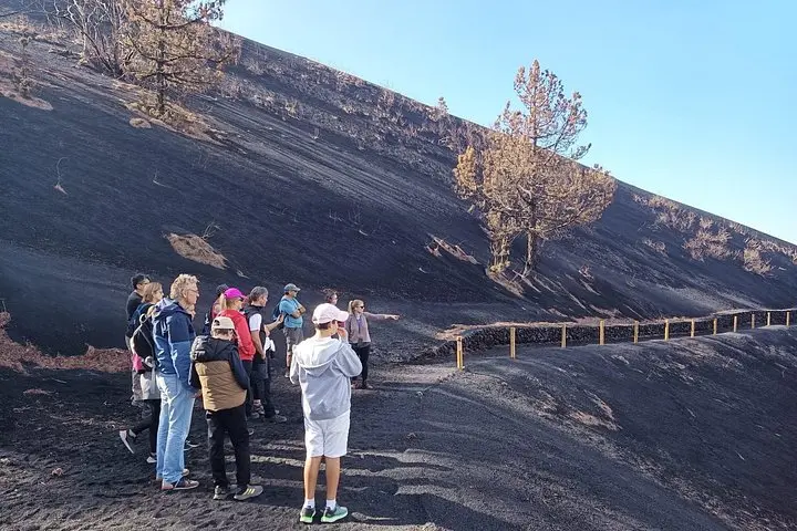
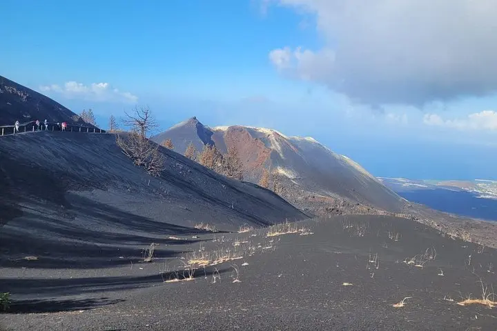
The trail opens on a wind-swept plateau above the Jable plain, where black lava fields still cool and the new cone of Tajogaite punctures the sky. Visitors begin at roughly 1,000 m altitude; the path drops into loose volcanic sand and then climbs back toward an authorized viewpoint that frames the fresh crater and the patchwork of scorched and recovering land below.
The trail opens on a wind-swept plateau above the Jable plain, where black lava fields still cool and the new cone of Tajogaite punctures the sky. Visitors begin at roughly 1,000 m altitude; the path drops into loose volcanic sand and then climbs back toward an authorized viewpoint that frames the fresh crater and the patchwork of scorched and recovering land below.
Geology here is immediate: recent lava flows, pahoehoe and ʻaʻā textures, and tephra deposits reveal an eruption that reshaped valleys and roads. Cumbre Vieja is the island’s active spine — eruptions have punctuated La Palma’s human history, most recently altering farmland, housing, and coastal contours in 2021. Guides often weave local stories of evacuation and recovery with explanations of magma chemistry, fault lines, and how wind and sea interact to distribute ash.
Culturally, the walk connects to island life: simple stone walls, abandoned plots, and pathways used for centuries by shepherds. The landscape feels alive — the cone demands attention, the wind pushes you forward, and gulls wheel above as the island reclaims edges.
Practical guidance: expect 7 km total with gradients from 4–23% over firm to loose malpais; allow 4–5 hours including stops. Wear sturdy, grippy boots and bring 2–3 liters of water, sun protection, and a windproof jacket. Trails and viewpoints can be legally restricted — follow guides and signage, keep to authorized routes, and plan for changeable mountain weather. This visit pairs geology and contemporary island resilience in a compact, demanding walk that rewards context as much as views.