THE ADVENTURE COLLECTIVE® · Independent discovery and booking for outdoor travel
A full-day guided hike from Cuajimoloyas explores pine–oak ridgelines, Zapotec village life and panoramic Sierra Norte views. Learn local forest stewardship, taste regional dishes and follow well-marked community trails.
A full-day guided hike from Cuajimoloyas explores pine–oak ridgelines, Zapotec village life and panoramic Sierra Norte views. Learn local forest stewardship, taste regional dishes and follow well-marked community trails.
You step off the minivan into thin, cool air and the pines seem to breathe around you, needles whispering as the trail rises. Cuajimoloyas perches on a high shoulder of the Sierra Norte de Oaxaca; mist rolls through gullies and views slice across ridgelines toward distant peaks.
Verified experiences and guided adventures in the surrounding area.
Operated by Oaxaca by locals · Cuajimoloyas, Oaxaca
You step off the minivan into thin, cool air and the pines seem to breathe around you, needles whispering as the trail rises. Cuajimoloyas perches on a high shoulder of the Sierra Norte de Oaxaca; mist rolls through gullies and views slice across ridgelines toward distant peaks.
The route threads through high-elevation pine–oak forest shaped by volcanic soils and millennia of erosion. This is Zapotec country: villages were established along these ridges for communal forestry and agriculture, and many families still practice usos y costumbres—local decision-making tied to land stewardship. Trail markers are clear, and paths often follow ancient footways once used to move people, goods and medicinal mushrooms between communities.
Expect footing of packed earth, exposed roots and occasional rocky ramps with modest elevation gains—this is a hike of steady climbs and open ridgelines rather than technical scrambling. The forest plays a role in the experience: thinned light under tall pines, the smell of resin, the call of jays and the distant drag of wind across high grass.
Practical guidance: start early to avoid afternoon cloud build-up and to see sweeping views before fog returns. Bring layered clothing—the temperature can shift 10–15°C between sun and shade—and rain protection in summer. Hydrate regularly; there are few services on the trail and the tour includes a local guide who links you to community-run stops for tasting regional dishes. Footwear with good traction and ankle support helps on rooty or wet sections. Respect community spaces: ask before photographing people and pack out all trash to support the villages’ conservation efforts.
A moderate fitness level is required—expect sustained uphill walking and uneven footing over several hours; no technical climbing is involved.
The tour includes stops with local hospitality and typical dishes provided by community hosts, but confirm specifics with the operator before booking.
Cuajimoloyas sits at high elevation where temperatures can drop; bring layers and be prepared for afternoon clouds or rain, especially in summer.
Older children who can handle multi-hour hikes and variable terrain will do fine; very young children or those with mobility issues may find it challenging.
Oaxaca by locals operates guided outdoor trips and adventures with an emphasis on safety, stewardship, and memorable experiences.
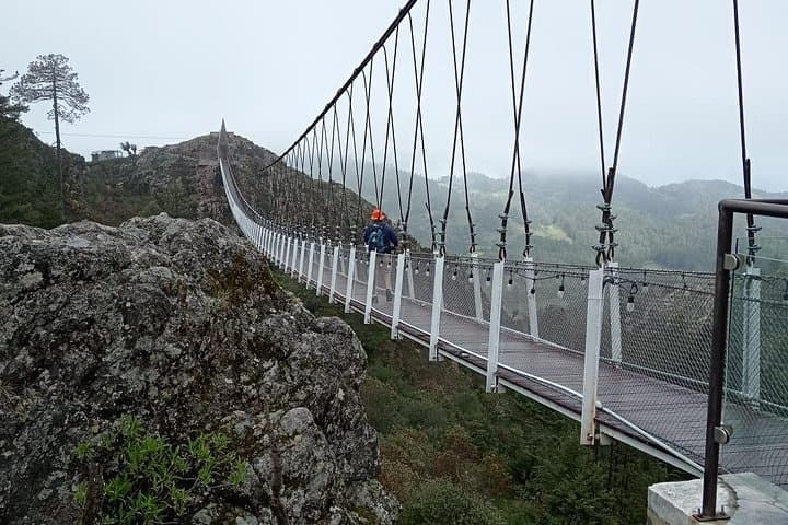


You step off the minivan into thin, cool air and the pines seem to breathe around you, needles whispering as the trail rises. Cuajimoloyas perches on a high shoulder of the Sierra Norte de Oaxaca; mist rolls through gullies and views slice across ridgelines toward distant peaks.
You step off the minivan into thin, cool air and the pines seem to breathe around you, needles whispering as the trail rises. Cuajimoloyas perches on a high shoulder of the Sierra Norte de Oaxaca; mist rolls through gullies and views slice across ridgelines toward distant peaks.
The route threads through high-elevation pine–oak forest shaped by volcanic soils and millennia of erosion. This is Zapotec country: villages were established along these ridges for communal forestry and agriculture, and many families still practice usos y costumbres—local decision-making tied to land stewardship. Trail markers are clear, and paths often follow ancient footways once used to move people, goods and medicinal mushrooms between communities.
Expect footing of packed earth, exposed roots and occasional rocky ramps with modest elevation gains—this is a hike of steady climbs and open ridgelines rather than technical scrambling. The forest plays a role in the experience: thinned light under tall pines, the smell of resin, the call of jays and the distant drag of wind across high grass.
Practical guidance: start early to avoid afternoon cloud build-up and to see sweeping views before fog returns. Bring layered clothing—the temperature can shift 10–15°C between sun and shade—and rain protection in summer. Hydrate regularly; there are few services on the trail and the tour includes a local guide who links you to community-run stops for tasting regional dishes. Footwear with good traction and ankle support helps on rooty or wet sections. Respect community spaces: ask before photographing people and pack out all trash to support the villages’ conservation efforts.
