THE ADVENTURE COLLECTIVE® · Independent discovery and booking for outdoor travel

Trace a medieval route from Rupit’s stone streets to Salt de Sallent, an 82m waterfall dropped into a canyon-like gorge. This day hike mixes historic architecture, volcanic rock underfoot and a short but rewarding forest approach to one of Catalonia’s most dramatic cascades.
Trace a medieval route from Rupit’s stone streets to Salt de Sallent, an 82m waterfall dropped into a canyon-like gorge. This day hike mixes historic architecture, volcanic rock underfoot and a short but rewarding forest approach to one of Catalonia’s most dramatic cascades.
Mornings in Rupit begin with stone lanes cooling under a pale Catalan light; the village’s bell tower punctures the sky and the hanging pedestrian bridge dares you toward the cliff edge. Walkers leave the compact historic center and drop into a fir-and-oak corridor that funnels toward the gorge, the ground turning to packed volcanic gravel from eruptions that shaped the region.
Verified experiences and guided adventures in the surrounding area.
Operated by Sacred Catalunia: Rupit, discovering the neighborhood. · Rupit i Pruit, Catalonia
Mornings in Rupit begin with stone lanes cooling under a pale Catalan light; the village’s bell tower punctures the sky and the hanging pedestrian bridge dares you toward the cliff edge. Walkers leave the compact historic center and drop into a fir-and-oak corridor that funnels toward the gorge, the ground turning to packed volcanic gravel from eruptions that shaped the region.
Rupit is a living medieval plan: 16th–17th century stone houses, lava-paved Fossar street and restrictions that keep modern façades at bay. The valley around Salt de Sallent is carved in sedimentary rock with abrupt cliffs that read like a small Catalan canyon — the waterfall itself plunges about 82 metres where creek meets cliff. Local lore speaks of witches and Inquisition-era stories; those myths live in the narrow streets and the names locals use for ridgelines.
Expect a mostly unmarked forest track, roots and loose stones underfoot, and seasonal swings — high flow in spring, a trickle in hot summers. Practical notes: allow 1–2 hours round-trip for the forest trail (longer if you explore gorges), pack layered clothing for cool canyon shade, and bring plenty of water — the route dips into cool shade and back into exposed viewpoints.
Navigation is straightforward but not highly signposted; a simple map or GPS track keeps you on the safest route. Respect historic structures and stay on trails to protect fragile soils; give wildlife space, and plan early or late in the day to avoid the heat and enjoy the best light for views and photos.
Driving is quickest (about 1.5 hours). Public transport exists but is limited—regional buses and connections via Vic may require transfers; check schedules in advance.
The forest trail from Rupit to the fall is typically 30–60 minutes one way depending on pace; allow more time for photos and exploring viewpoints.
No—flows peak in spring after rains and snowmelt; in hot, dry summers the stream can be greatly reduced or patchy.
Dogs are usually permitted but must be kept on a leash to protect wildlife and respect the historic village and narrow paths.
Sacred Catalunia: Rupit, discovering the neighborhood. operates guided outdoor trips and adventures with an emphasis on safety, stewardship, and memorable experiences.
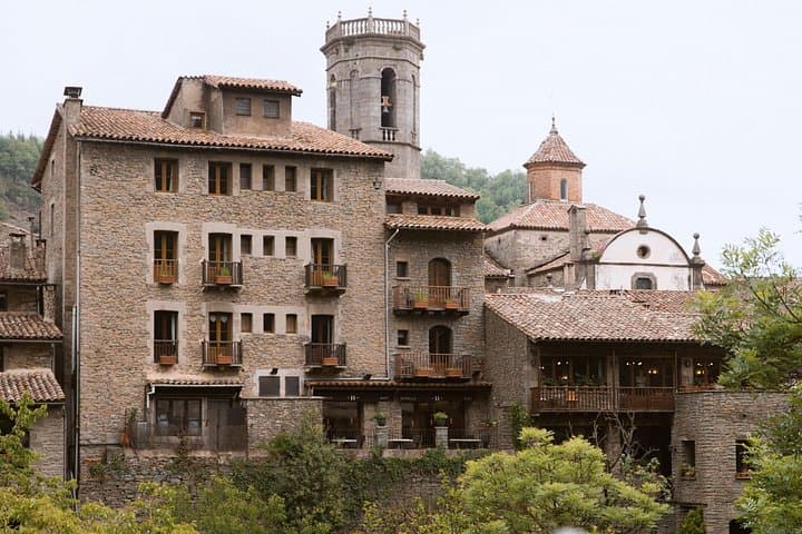
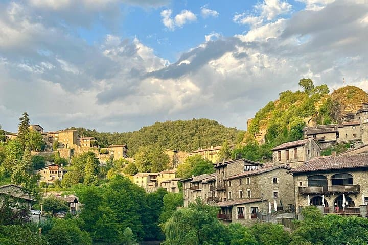


Mornings in Rupit begin with stone lanes cooling under a pale Catalan light; the village’s bell tower punctures the sky and the hanging pedestrian bridge dares you toward the cliff edge. Walkers leave the compact historic center and drop into a fir-and-oak corridor that funnels toward the gorge, the ground turning to packed volcanic gravel from eruptions that shaped the region.
Mornings in Rupit begin with stone lanes cooling under a pale Catalan light; the village’s bell tower punctures the sky and the hanging pedestrian bridge dares you toward the cliff edge. Walkers leave the compact historic center and drop into a fir-and-oak corridor that funnels toward the gorge, the ground turning to packed volcanic gravel from eruptions that shaped the region.
Rupit is a living medieval plan: 16th–17th century stone houses, lava-paved Fossar street and restrictions that keep modern façades at bay. The valley around Salt de Sallent is carved in sedimentary rock with abrupt cliffs that read like a small Catalan canyon — the waterfall itself plunges about 82 metres where creek meets cliff. Local lore speaks of witches and Inquisition-era stories; those myths live in the narrow streets and the names locals use for ridgelines.
Expect a mostly unmarked forest track, roots and loose stones underfoot, and seasonal swings — high flow in spring, a trickle in hot summers. Practical notes: allow 1–2 hours round-trip for the forest trail (longer if you explore gorges), pack layered clothing for cool canyon shade, and bring plenty of water — the route dips into cool shade and back into exposed viewpoints.
Navigation is straightforward but not highly signposted; a simple map or GPS track keeps you on the safest route. Respect historic structures and stay on trails to protect fragile soils; give wildlife space, and plan early or late in the day to avoid the heat and enjoy the best light for views and photos.