THE ADVENTURE COLLECTIVE® · Independent discovery and booking for outdoor travel

A 5.5km guided hike through Kata Tjuta's Valley of the Winds that combines geological spectacle, Anangu cultural insights and challenging desert terrain. This guide explains what to expect, how to prepare, and where to find the best light for photos.
A 5.5km guided hike through Kata Tjuta's Valley of the Winds that combines geological spectacle, Anangu cultural insights and challenging desert terrain. This guide explains what to expect, how to prepare, and where to find the best light for photos.
You pull up at the dune viewing platform just before dawn and the domes of Kata Tjuta sit like a weathered fleet against a pale sky. Wind moves through the valleys before you do—whistling along the corrugated rock, teasing up dust, and outlining the shoulders of each dome in crisp light. Your driver-guide points out tracks, explains the itinerary and the local Anangu names, and by the time you lace boots the air tastes of iron and eucalyptus.
Verified experiences and guided adventures in the surrounding area.
You pull up at the dune viewing platform just before dawn and the domes of Kata Tjuta sit like a weathered fleet against a pale sky. Wind moves through the valleys before you do—whistling along the corrugated rock, teasing up dust, and outlining the shoulders of each dome in crisp light. Your driver-guide points out tracks, explains the itinerary and the local Anangu names, and by the time you lace boots the air tastes of iron and eucalyptus.
The Valley of the Winds track threads 5.5 kilometres of creek beds, rocky saddlebacks and open ridgelines that have been shaped over half a billion years. Geologically, the domes are the eroded remnants of a colossal mountain range; the conglomerate rock has been compressed into rounded, banded domes that shrug off the desert sun. Culturally the place is older than maps: for the Anangu people Kata Tjuta holds creation stories and songlines, and sections of the valley are still managed under traditional law. Guides typically offer cultural context—place names, how certain plants were used, and why some areas are restricted for ceremonial reasons.
The walk is not a gentle garden stroll. Creek beds dig into the route, short steep pitches demand sure footing, and the open sections expose you to the sun and wind. Yet that challenge is part of the reward; each ridge delivers new perspectives, and the valley squeezes into a green corridor where desert wattles and spinifex hug cool pockets of shade. Wildlife pays a passing interest—wallabies, wedge-tailed eagles and small reptiles out on their own schedules—so move quietly and carry out what you carry in.
Practical guidance: the full guided outing including transport and interpretive commentary runs roughly 3–4 hours on the trail with total tour time longer if your operator includes transfers from Yulara. Wear sturdy hiking shoes with good grip—there’s loose rock and short scrambles. Carry at least 2–3 litres of water in hot months, plus sun protection: wide-brimmed hat, SPF, and lightweight long sleeves. Start early to avoid peak heat and to catch the light that sculpts the domes into sharp relief. Check access rules—some areas may be closed during extreme weather or for cultural reasons.
For photographers, sunrise and late afternoon offer the richest color on the rock faces; binoculars reward those who want to scan gullies for birds of prey. Respect signage and stay on the trail—erosion and sacred site protection depend on small decisions made by each visitor.
This is a desert hike that asks you to pay attention: to the rock, the sky, and the histories written into the land. Walk with curiosity, pack with purpose, and you’ll come away with more than photos—you’ll have a clearer sense of how ancient patience carved these domes and why they still matter.
The full track used in guided visits is about 5.5 kilometres; allow 3–4 hours for a comfortable pace with stops.
Older children who are used to walking on uneven terrain can manage it, but the heat and exposure make early starts and close supervision important.
Visitors require entry to Uluru-Kata Tjuta National Park, which is a paid park pass; your tour operator typically handles this for you.
Guides are not legally required for the trail, but a driver-guide enhances cultural understanding and handles logistics and safety in remote conditions.
Common sightings include wallabies, perentie or other lizards, and raptors such as wedge-tailed eagles; wildlife is most active in cooler hours.
No—there are creek beds but they are not reliable water sources; treat the area as arid and carry all water you need.
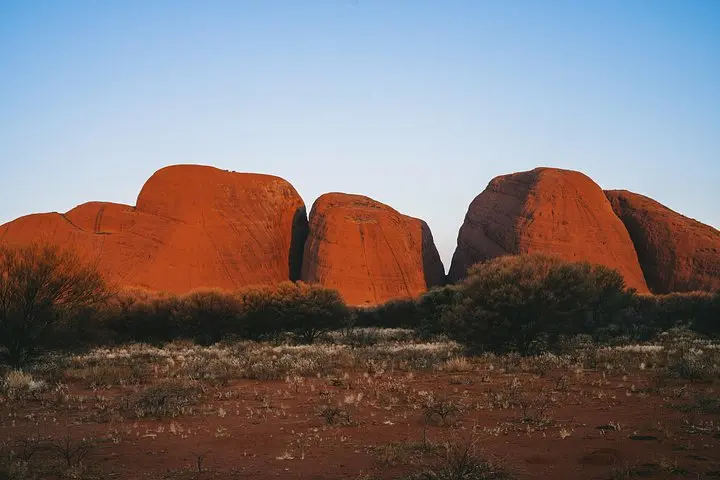
You pull up at the dune viewing platform just before dawn and the domes of Kata Tjuta sit like a weathered fleet against a pale sky. Wind moves through the valleys before you do—whistling along the corrugated rock, teasing up dust, and outlining the shoulders of each dome in crisp light. Your driver-guide points out tracks, explains the itinerary and the local Anangu names, and by the time you lace boots the air tastes of iron and eucalyptus.
You pull up at the dune viewing platform just before dawn and the domes of Kata Tjuta sit like a weathered fleet against a pale sky. Wind moves through the valleys before you do—whistling along the corrugated rock, teasing up dust, and outlining the shoulders of each dome in crisp light. Your driver-guide points out tracks, explains the itinerary and the local Anangu names, and by the time you lace boots the air tastes of iron and eucalyptus.
The Valley of the Winds track threads 5.5 kilometres of creek beds, rocky saddlebacks and open ridgelines that have been shaped over half a billion years. Geologically, the domes are the eroded remnants of a colossal mountain range; the conglomerate rock has been compressed into rounded, banded domes that shrug off the desert sun. Culturally the place is older than maps: for the Anangu people Kata Tjuta holds creation stories and songlines, and sections of the valley are still managed under traditional law. Guides typically offer cultural context—place names, how certain plants were used, and why some areas are restricted for ceremonial reasons.
The walk is not a gentle garden stroll. Creek beds dig into the route, short steep pitches demand sure footing, and the open sections expose you to the sun and wind. Yet that challenge is part of the reward; each ridge delivers new perspectives, and the valley squeezes into a green corridor where desert wattles and spinifex hug cool pockets of shade. Wildlife pays a passing interest—wallabies, wedge-tailed eagles and small reptiles out on their own schedules—so move quietly and carry out what you carry in.
Practical guidance: the full guided outing including transport and interpretive commentary runs roughly 3–4 hours on the trail with total tour time longer if your operator includes transfers from Yulara. Wear sturdy hiking shoes with good grip—there’s loose rock and short scrambles. Carry at least 2–3 litres of water in hot months, plus sun protection: wide-brimmed hat, SPF, and lightweight long sleeves. Start early to avoid peak heat and to catch the light that sculpts the domes into sharp relief. Check access rules—some areas may be closed during extreme weather or for cultural reasons.
For photographers, sunrise and late afternoon offer the richest color on the rock faces; binoculars reward those who want to scan gullies for birds of prey. Respect signage and stay on the trail—erosion and sacred site protection depend on small decisions made by each visitor.
This is a desert hike that asks you to pay attention: to the rock, the sky, and the histories written into the land. Walk with curiosity, pack with purpose, and you’ll come away with more than photos—you’ll have a clearer sense of how ancient patience carved these domes and why they still matter.