THE ADVENTURE COLLECTIVE® · Independent discovery and booking for outdoor travel

Eight days on the Lemosho Route gives you the best shot at summiting Kilimanjaro in daylight and at sunrise. Scenic Shira Plateau, Barranco Wall and the final push to Uhuru Peak are balanced with deliberate acclimatization and an experienced crew.
Eight days on the Lemosho Route gives you the best shot at summiting Kilimanjaro in daylight and at sunrise. Scenic Shira Plateau, Barranco Wall and the final push to Uhuru Peak are balanced with deliberate acclimatization and an experienced crew.
The wind on Kilimanjaro does not roar; it negotiates. On the first morning, you leave the eucalyptus and banana groves below Moshi and drive toward Londorossi Gate, where the trail peels off into heathland and the mountain’s wide shoulders. As the Lemosho Route lifts onto the Shira Plateau, the landscape changes like pages turning: forest, moorland, alpine desert and finally the stony lip of Kibo crater. The route is designed to favor acclimatization—eight days gives your lungs a fighting chance to catch up with the altitude.
Verified experiences and guided adventures in the surrounding area.
Operated by Kilimanjaro Brothers · Moshi, Kilimanjaro Region
The wind on Kilimanjaro does not roar; it negotiates. On the first morning, you leave the eucalyptus and banana groves below Moshi and drive toward Londorossi Gate, where the trail peels off into heathland and the mountain’s wide shoulders. As the Lemosho Route lifts onto the Shira Plateau, the landscape changes like pages turning: forest, moorland, alpine desert and finally the stony lip of Kibo crater. The route is designed to favor acclimatization—eight days gives your lungs a fighting chance to catch up with the altitude.
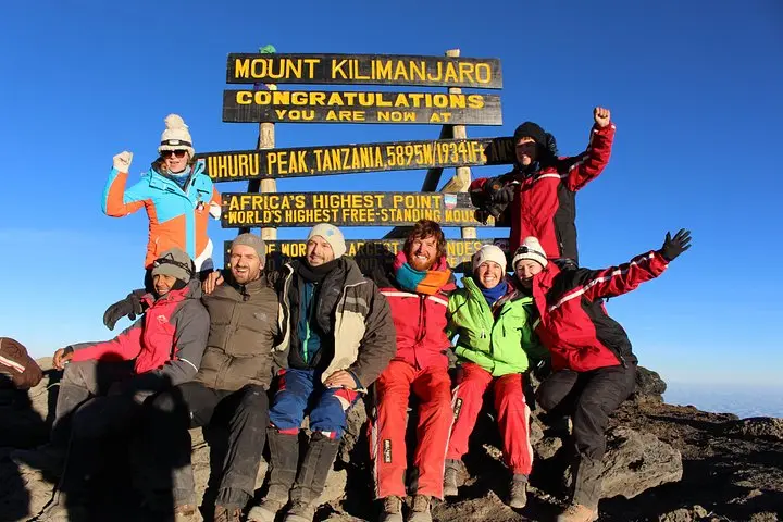
Kilimanjaro is a volcanic massif perched at the edge of the East African Rift. Geology here is visible in layers: the flat basalt of Shira, the jagged scoria of the Kibo cone and the ragged ice fields near Uhuru Peak (5,895 m / 19,341 ft). The Lemosho approach arrives from the mountain’s west, crossing Shira Plateau, then swinging north and east to meet the southern circuit through Barranco, Karanga and Barafu before the summit push. Historically the mountain drew explorers in the 19th century; Hans Meyer’s first recorded ascent in 1889 opened the modern era of commercial climbs and a complicated legacy of conservation and local labor.
You’ll notice life clinging to these slopes: the lower cloud forest hosts colobus monkeys and a chorus of birds; higher up the vegetation gives way to giant lobelia and the exposed, wind-gnawed grit of the alpine zone. Porters and guides are not background characters here—they are essential. Ethical treatment of staff and sensible load limits make the climb safer and more sustainable.
Practical note: expect daily hiking of 3–8 hours. Day distances are modest—4–8 km between camps—but altitude amplifies every step. Summit night is the longest push: roughly 5 km up from Barafu to the crater rim, usually 7–8 hours in subzero temperatures, then a long descent to Mweka Camp. Terrain varies from forested trails to rocky, loose scree and a final stretch of volcanic gravel. Waterproof boots with good ankle support, layered insulation and a reliable headlamp are musts.
Acclimatize proactively: stay well-hydrated, eat calorie-dense meals provided by your crew, and use the extra nights and shorter hiking days to let your body adapt. For photographers, dawn on the Shira Plateau and the crater rim at sunrise deliver dramatic silhouettes; for softer memories, watch the valley clouds retreat under your feet the morning after Barranco. This is a route that rewards planning, patience and a respect for altitude—get those three right and the mountain will yield its greatest view.
You should have good aerobic fitness and experience with multi-day hikes; technical climbing skills are not required but training on long ascents, backpack comfort and altitude conditioning helps.
Altitude sickness is the primary risk; adequate acclimatization, monitoring oxygen using pulse oximeters, and experienced guides mitigate this. Cold exposure on summit night is another concern.
The best windows are late June–October (dry) and late December–February; avoid the long rains (March–May) when trails are muddy and conditions wetter.
Yes, experienced English-speaking guides, porters and full board meals are included in this itinerary; fair treatment and porter load limits are part of the operator’s package.
Climb permits and park fees are included by the operator; you do not need to arrange separate permits but should carry ID for registration.
Yes—Moshi has several rental shops for sleeping bags, down jackets and crampons, but bring broken-in boots and personal items for hygiene and fit.
Kilimanjaro Brothers operates guided outdoor trips and adventures with an emphasis on safety, stewardship, and memorable experiences.
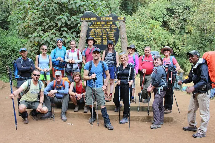
The wind on Kilimanjaro does not roar; it negotiates. On the first morning, you leave the eucalyptus and banana groves below Moshi and drive toward Londorossi Gate, where the trail peels off into heathland and the mountain’s wide shoulders. As the Lemosho Route lifts onto the Shira Plateau, the landscape changes like pages turning: forest, moorland, alpine desert and finally the stony lip of Kibo crater. The route is designed to favor acclimatization—eight days gives your lungs a fighting chance to catch up with the altitude.
The wind on Kilimanjaro does not roar; it negotiates. On the first morning, you leave the eucalyptus and banana groves below Moshi and drive toward Londorossi Gate, where the trail peels off into heathland and the mountain’s wide shoulders. As the Lemosho Route lifts onto the Shira Plateau, the landscape changes like pages turning: forest, moorland, alpine desert and finally the stony lip of Kibo crater. The route is designed to favor acclimatization—eight days gives your lungs a fighting chance to catch up with the altitude.
Kilimanjaro is a volcanic massif perched at the edge of the East African Rift. Geology here is visible in layers: the flat basalt of Shira, the jagged scoria of the Kibo cone and the ragged ice fields near Uhuru Peak (5,895 m / 19,341 ft). The Lemosho approach arrives from the mountain’s west, crossing Shira Plateau, then swinging north and east to meet the southern circuit through Barranco, Karanga and Barafu before the summit push. Historically the mountain drew explorers in the 19th century; Hans Meyer’s first recorded ascent in 1889 opened the modern era of commercial climbs and a complicated legacy of conservation and local labor.
You’ll notice life clinging to these slopes: the lower cloud forest hosts colobus monkeys and a chorus of birds; higher up the vegetation gives way to giant lobelia and the exposed, wind-gnawed grit of the alpine zone. Porters and guides are not background characters here—they are essential. Ethical treatment of staff and sensible load limits make the climb safer and more sustainable.
Practical note: expect daily hiking of 3–8 hours. Day distances are modest—4–8 km between camps—but altitude amplifies every step. Summit night is the longest push: roughly 5 km up from Barafu to the crater rim, usually 7–8 hours in subzero temperatures, then a long descent to Mweka Camp. Terrain varies from forested trails to rocky, loose scree and a final stretch of volcanic gravel. Waterproof boots with good ankle support, layered insulation and a reliable headlamp are musts.
Acclimatize proactively: stay well-hydrated, eat calorie-dense meals provided by your crew, and use the extra nights and shorter hiking days to let your body adapt. For photographers, dawn on the Shira Plateau and the crater rim at sunrise deliver dramatic silhouettes; for softer memories, watch the valley clouds retreat under your feet the morning after Barranco. This is a route that rewards planning, patience and a respect for altitude—get those three right and the mountain will yield its greatest view.