THE ADVENTURE COLLECTIVE® · Independent discovery and booking for outdoor travel

A compact, high‑value Himalayan trek that moves from pine forests to glacial meadows, the Langtang Valley route offers jaw‑opening views of Langtang Lirung and cultural stops at mountain gompas. This 6‑day itinerary balances acclimatization with sustained alpine scenery.
A compact, high‑value Himalayan trek that moves from pine forests to glacial meadows, the Langtang Valley route offers jaw‑opening views of Langtang Lirung and cultural stops at mountain gompas. This 6‑day itinerary balances acclimatization with sustained alpine scenery.
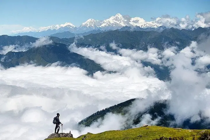
You step off the dusty Kathmandu road and into a cooler, conifer-scented world: pine trunks close in, a mountain stream dares you to keep pace, and switchbacks climb past tea houses whose stoves smoke against a blue-silver skyline. The Langtang Valley trek moves steadily from inhabited terraces into raw glacial country, with Langtang Lirung (7,246 m) watching like a patient giant.
Verified experiences and guided adventures in the surrounding area.
Operated by Pariwar Holidays Pvt Ltd · Syabrubesi, Bagmati Province
You step off the dusty Kathmandu road and into a cooler, conifer-scented world: pine trunks close in, a mountain stream dares you to keep pace, and switchbacks climb past tea houses whose stoves smoke against a blue-silver skyline. The Langtang Valley trek moves steadily from inhabited terraces into raw glacial country, with Langtang Lirung (7,246 m) watching like a patient giant.
The valley sits on the southern slopes of the central Himalaya, carved by glaciers and lined with moraines, boulder fields and alpine meadows. Human history here is visible in stone gompas and mani walls—Tibetan-Buddhist culture folded into daily life—and in settlements that trade yak cheese and highland barley. Geologically, Langtang’s U-shaped valley and hanging glaciers reflect active uplift and perennial ice; expect moraine ridges and occasional rockfall zones on higher approaches.
Practically: this itinerary runs roughly six days from the trailhead to Kyanjin Gompa and back, about 50–60 km round-trip with 2,200–2,800 m cumulative elevation gain depending on route and side excursions (Kyanjin Ri sits near 4,700 m). Trails vary from packed dirt and stone staircases to scree and glacial moraine. Tea houses provide simple lodging and meals, but sleep is basic and spare parts of the trail can be icy outside summer.
Plan for altitude pacing, layered insulation, good boots and a water-treatment plan. Start early to avoid afternoon clouds and give yourself an extra acclimatization day if you aim for Kyanjin Ri. Respect local rules inside Langtang National Park and carry permits—this is mountain travel that rewards preparation as much as curiosity.
Yes—trekkers must carry a TIMS card and a Langtang National Park permit; your operator typically arranges these before departure.
The common high point is Kyanjin Gompa (≈3,870 m) with optional Kyanjin Ri (~4,700 m); expect cumulative gain from trailhead around 2,200–2,800 m.
Yes—basic tea houses offer dorms or twin rooms and meals; bring cash, a warm sleeping bag and small comforts.
Acute mountain sickness is possible; ascend slowly, hydrate, watch symptoms and descend if severe—carry medications only if advised by a physician.
Pariwar Holidays Pvt Ltd operates guided outdoor trips and adventures with an emphasis on safety, stewardship, and memorable experiences.
You step off the dusty Kathmandu road and into a cooler, conifer-scented world: pine trunks close in, a mountain stream dares you to keep pace, and switchbacks climb past tea houses whose stoves smoke against a blue-silver skyline. The Langtang Valley trek moves steadily from inhabited terraces into raw glacial country, with Langtang Lirung (7,246 m) watching like a patient giant.
You step off the dusty Kathmandu road and into a cooler, conifer-scented world: pine trunks close in, a mountain stream dares you to keep pace, and switchbacks climb past tea houses whose stoves smoke against a blue-silver skyline. The Langtang Valley trek moves steadily from inhabited terraces into raw glacial country, with Langtang Lirung (7,246 m) watching like a patient giant.
The valley sits on the southern slopes of the central Himalaya, carved by glaciers and lined with moraines, boulder fields and alpine meadows. Human history here is visible in stone gompas and mani walls—Tibetan-Buddhist culture folded into daily life—and in settlements that trade yak cheese and highland barley. Geologically, Langtang’s U-shaped valley and hanging glaciers reflect active uplift and perennial ice; expect moraine ridges and occasional rockfall zones on higher approaches.
Practically: this itinerary runs roughly six days from the trailhead to Kyanjin Gompa and back, about 50–60 km round-trip with 2,200–2,800 m cumulative elevation gain depending on route and side excursions (Kyanjin Ri sits near 4,700 m). Trails vary from packed dirt and stone staircases to scree and glacial moraine. Tea houses provide simple lodging and meals, but sleep is basic and spare parts of the trail can be icy outside summer.
Plan for altitude pacing, layered insulation, good boots and a water-treatment plan. Start early to avoid afternoon clouds and give yourself an extra acclimatization day if you aim for Kyanjin Ri. Respect local rules inside Langtang National Park and carry permits—this is mountain travel that rewards preparation as much as curiosity.