THE ADVENTURE COLLECTIVE® · Independent discovery and booking for outdoor travel

A half-day climb from Ma On Shan Village to Ngong Ping Plateau delivers 400-meter views over Sai Kung’s islands and the dramatic ridgeline used by hang gliders. This practical guide explains what to expect, how to prepare, and local highlights to look for.
A half-day climb from Ma On Shan Village to Ngong Ping Plateau delivers 400-meter views over Sai Kung’s islands and the dramatic ridgeline used by hang gliders. This practical guide explains what to expect, how to prepare, and local highlights to look for.
A narrow footpath slips upward through shaded secondary forest, the undergrowth parting as hikers climb toward a low, broad rim. After forty to sixty minutes of steady ascent the trail opens onto Ngong Ping Plateau; the air thins, islands sit like inked stamps on the South China Sea, and hang gliders queue the wind with patient wings.
Verified experiences and guided adventures in the surrounding area.
Operated by Walk Hong Kong Limited · Ma On Shan, New Territories
A narrow footpath slips upward through shaded secondary forest, the undergrowth parting as hikers climb toward a low, broad rim. After forty to sixty minutes of steady ascent the trail opens onto Ngong Ping Plateau; the air thins, islands sit like inked stamps on the South China Sea, and hang gliders queue the wind with patient wings.
The route begins at Ma On Shan Village, once Hong Kong's largest iron-mining settlement. Miners hauled ore along the same ridgeline routes until the mine closed in 1976. Geologically the ridge is a mix of volcanic and granitic outcrops; Pyramid Hill’s shape and the plateau’s hard rock explain why hang gliders prize the launch. Culturally, these paths were market arteries—villagers carried goods over the hill toward Kowloon for decades.
Expect narrow singletrack, stone steps carved by long use, and occasional exposed roots. The plateau sits around 400 m above sea level and rewards the climb with expansive views of Sai Kung’s sheltered bays and scattered islets. Winds can push unexpectedly; the same breeze that fills a glider will cold-shock an unprepared hiker.
Practical guidance: start early to avoid midday heat and checking tide or ferry schedules if you plan to linger in Sai Kung Village. Wear grippy footwear for rocky steps and bring 1–2 liters of water, sunscreen, and a light windbreaker. Navigation is straightforward on marked trails, but be ready for steep descents on ancient village paths. The hike finishes in Sai Kung — either return with the guide or sample seafood and a cooled drink at the waterfront.
The trail is moderate: steady uphill for about an hour with some rocky and rooty sections; beginners with basic fitness can complete it with breaks.
Yes—children aged 8+ are suitable but should be supervised; some sections are exposed and require careful footing.
The tour offers transfers back with the guide; alternatively you can stay in Sai Kung and return independently by public transport or taxi.
Early morning provides cooler temperatures and clearer visibility; late afternoon can bring stronger winds and haze that reduce views.
Walk Hong Kong Limited operates guided outdoor trips and adventures with an emphasis on safety, stewardship, and memorable experiences.
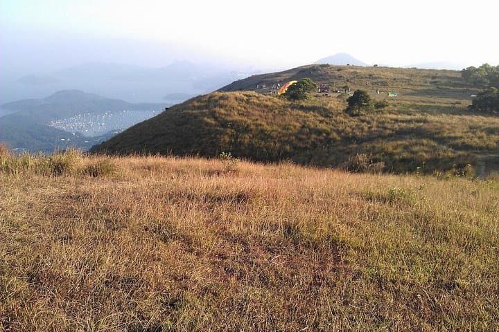


A narrow footpath slips upward through shaded secondary forest, the undergrowth parting as hikers climb toward a low, broad rim. After forty to sixty minutes of steady ascent the trail opens onto Ngong Ping Plateau; the air thins, islands sit like inked stamps on the South China Sea, and hang gliders queue the wind with patient wings.
A narrow footpath slips upward through shaded secondary forest, the undergrowth parting as hikers climb toward a low, broad rim. After forty to sixty minutes of steady ascent the trail opens onto Ngong Ping Plateau; the air thins, islands sit like inked stamps on the South China Sea, and hang gliders queue the wind with patient wings.
The route begins at Ma On Shan Village, once Hong Kong's largest iron-mining settlement. Miners hauled ore along the same ridgeline routes until the mine closed in 1976. Geologically the ridge is a mix of volcanic and granitic outcrops; Pyramid Hill’s shape and the plateau’s hard rock explain why hang gliders prize the launch. Culturally, these paths were market arteries—villagers carried goods over the hill toward Kowloon for decades.
Expect narrow singletrack, stone steps carved by long use, and occasional exposed roots. The plateau sits around 400 m above sea level and rewards the climb with expansive views of Sai Kung’s sheltered bays and scattered islets. Winds can push unexpectedly; the same breeze that fills a glider will cold-shock an unprepared hiker.
Practical guidance: start early to avoid midday heat and checking tide or ferry schedules if you plan to linger in Sai Kung Village. Wear grippy footwear for rocky steps and bring 1–2 liters of water, sunscreen, and a light windbreaker. Navigation is straightforward on marked trails, but be ready for steep descents on ancient village paths. The hike finishes in Sai Kung — either return with the guide or sample seafood and a cooled drink at the waterfront.