THE ADVENTURE COLLECTIVE® · Independent discovery and booking for outdoor travel

Follow the Budhi Gandaki from lowland farms to the Larkya La high pass on a 12–14 day Manaslu Circuit trek. Expect teahouse nights, high‑altitude gains and deep Tibetan cultural encounters.
Follow the Budhi Gandaki from lowland farms to the Larkya La high pass on a 12–14 day Manaslu Circuit trek. Expect teahouse nights, high‑altitude gains and deep Tibetan cultural encounters.
A cold morning fog lifts off the Budhi Gandaki and the valley exhales — prayer flags snap as you shoulder your pack and follow a trail that climbs from rice terraces into pine and rhododendron forest. The river below dares you forward, its roar a steady metronome as the trail gains steeply toward villages where Tibetan culture still sets the pace.
Verified experiences and guided adventures in the surrounding area.
Operated by Himalayan Advisor Pvt. Ltd. · Soti Khola, Gandaki Province
A cold morning fog lifts off the Budhi Gandaki and the valley exhales — prayer flags snap as you shoulder your pack and follow a trail that climbs from rice terraces into pine and rhododendron forest. The river below dares you forward, its roar a steady metronome as the trail gains steeply toward villages where Tibetan culture still sets the pace.
Manaslu (8,164 m) dominates the skyline and gives the circuit its name. Geologically the range is young and rugged, carved by glaciation and the Budhi Gandaki cutting an energetic gorge. The trail traces ancient trade routes and passes mani walls, monasteries and stone-built villages inhabited by Himalayan Tibetan communities for centuries.
Expect a 12–14 day loop of roughly 150–180 km with daily hikes of 4–7 hours and a maximum altitude at the Larkya La pass (around 5,160 m). Terrain alternates farm tracks, suspension bridges, rocky ledges and high alpine scree. Accommodation is primarily twin‑share teahouses; meals are full‑board through the trek. Guides and porters are common and recommended for navigation, logistics and acclimatization.
Practical edge: prioritize staged ascent and hydration to reduce altitude risk, bring layered clothing for wide temperature swings, and carry cash for remote village purchases. Permit systems protect the region — carry originals and photocopies. Start from Soti Khola (800 m), pass Samagaun and Samdo, crest Larkya La, then descend toward Bimthang and Besi Sahar. The route rewards with panoramas of snow faces, monastery art, and the steady, human rhythm of high Himalayan life.
Yes — the Manaslu Restricted Area Permit and Manaslu Conservation Area Permit are required; travel normally through licensed operators who arrange permits.
No technical climbing gear is needed for the standard Larkya La route, but the pass reaches ~5,160 m and involves steep, sometimes icy sections where experience helps.
Teahouse accommodation (twin‑share rooms) with basic amenities; facilities and hot water vary by village and altitude.
Autumn (Sept–Nov) and spring (Mar–May) offer the most stable weather and best visibility; monsoon season brings rain and leeches, while winter is cold and access is limited.
Himalayan Advisor Pvt. Ltd. operates guided outdoor trips and adventures with an emphasis on safety, stewardship, and memorable experiences.


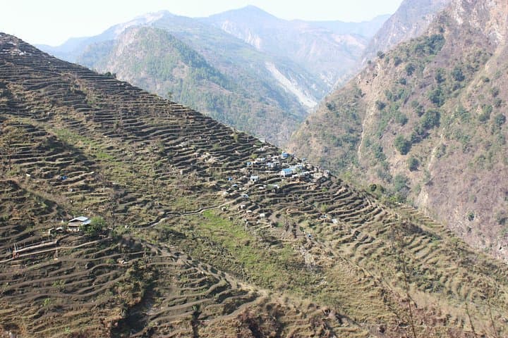

A cold morning fog lifts off the Budhi Gandaki and the valley exhales — prayer flags snap as you shoulder your pack and follow a trail that climbs from rice terraces into pine and rhododendron forest. The river below dares you forward, its roar a steady metronome as the trail gains steeply toward villages where Tibetan culture still sets the pace.
A cold morning fog lifts off the Budhi Gandaki and the valley exhales — prayer flags snap as you shoulder your pack and follow a trail that climbs from rice terraces into pine and rhododendron forest. The river below dares you forward, its roar a steady metronome as the trail gains steeply toward villages where Tibetan culture still sets the pace.
Manaslu (8,164 m) dominates the skyline and gives the circuit its name. Geologically the range is young and rugged, carved by glaciation and the Budhi Gandaki cutting an energetic gorge. The trail traces ancient trade routes and passes mani walls, monasteries and stone-built villages inhabited by Himalayan Tibetan communities for centuries.
Expect a 12–14 day loop of roughly 150–180 km with daily hikes of 4–7 hours and a maximum altitude at the Larkya La pass (around 5,160 m). Terrain alternates farm tracks, suspension bridges, rocky ledges and high alpine scree. Accommodation is primarily twin‑share teahouses; meals are full‑board through the trek. Guides and porters are common and recommended for navigation, logistics and acclimatization.
Practical edge: prioritize staged ascent and hydration to reduce altitude risk, bring layered clothing for wide temperature swings, and carry cash for remote village purchases. Permit systems protect the region — carry originals and photocopies. Start from Soti Khola (800 m), pass Samagaun and Samdo, crest Larkya La, then descend toward Bimthang and Besi Sahar. The route rewards with panoramas of snow faces, monastery art, and the steady, human rhythm of high Himalayan life.