THE ADVENTURE COLLECTIVE® · Independent discovery and booking for outdoor travel

A private full-day hike up Pacaya takes you from coffee farm roads to black lava fields and steaming vents. Expect loose volcanic terrain, 4–6 km of walking and dramatic views of neighboring cones—best tackled with a local guide.
A private full-day hike up Pacaya takes you from coffee farm roads to black lava fields and steaming vents. Expect loose volcanic terrain, 4–6 km of walking and dramatic views of neighboring cones—best tackled with a local guide.
Morning light from Antigua compresses into a narrow ribbon as the van climbs toward Pacaya. The trail opens from cloud-scrubbed coffee farms into a moonscape of black cinders; steam rises from hot seams and the air sometimes smells faintly of sulfur. You move deliberately over loose volcanic gravel, the mountain seeming to push back with every step, while distant cones—Agua and Fuego—track the sky like watchful neighbors.
Verified experiences and guided adventures in the surrounding area.
Morning light from Antigua compresses into a narrow ribbon as the van climbs toward Pacaya. The trail opens from cloud-scrubbed coffee farms into a moonscape of black cinders; steam rises from hot seams and the air sometimes smells faintly of sulfur. You move deliberately over loose volcanic gravel, the mountain seeming to push back with every step, while distant cones—Agua and Fuego—track the sky like watchful neighbors.
Pacaya is one of Guatemala’s most active volcanoes and a visible chapter of the Central American Volcanic Arc. Geologically young, its flanks are covered in recent lava fields and tephra; human history around Pacaya is a mix of rural villages, coffee cultivation, and tours that have grown since the late 20th century. Local guides often point out lava flows and explain how eruptions remodel the landscape in seasons.
Expect a sustained uphill route of roughly 4–6 km round trip with 500–700 m of elevation gain, mostly on loose volcanic sand, ash and broken rock; total tour time is commonly about six hours from pickup to return. The route can be steep and dusty; windproof layers and sturdy boots matter as much as water. When volcanic activity permits, the upper slopes offer steaming vents and hardened lava you can approach under guide direction—some operators even let you toast marshmallows on warm stones.
Plan for sun and wind, travel with a certified guide, and allow extra time for slow pacing on unstable ground. Respect posted closures—safety and conservation go hand in hand on this dramatic, living landscape.
The hike itself is typically 3–4 hours round trip; private tours commonly run about six hours including transport from Antigua.
Safety depends on current volcanic activity—operators monitor conditions and will close access if vents or lava flows make the route unsafe.
Yes, if you are reasonably fit and take a steady pace; choose a private guided tour so the guide can match the pace to your group.
Facilities are limited to the trailhead and nearby villages—plan accordingly and pack out waste when required.
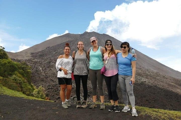
Morning light from Antigua compresses into a narrow ribbon as the van climbs toward Pacaya. The trail opens from cloud-scrubbed coffee farms into a moonscape of black cinders; steam rises from hot seams and the air sometimes smells faintly of sulfur. You move deliberately over loose volcanic gravel, the mountain seeming to push back with every step, while distant cones—Agua and Fuego—track the sky like watchful neighbors.
Morning light from Antigua compresses into a narrow ribbon as the van climbs toward Pacaya. The trail opens from cloud-scrubbed coffee farms into a moonscape of black cinders; steam rises from hot seams and the air sometimes smells faintly of sulfur. You move deliberately over loose volcanic gravel, the mountain seeming to push back with every step, while distant cones—Agua and Fuego—track the sky like watchful neighbors.
Pacaya is one of Guatemala’s most active volcanoes and a visible chapter of the Central American Volcanic Arc. Geologically young, its flanks are covered in recent lava fields and tephra; human history around Pacaya is a mix of rural villages, coffee cultivation, and tours that have grown since the late 20th century. Local guides often point out lava flows and explain how eruptions remodel the landscape in seasons.
Expect a sustained uphill route of roughly 4–6 km round trip with 500–700 m of elevation gain, mostly on loose volcanic sand, ash and broken rock; total tour time is commonly about six hours from pickup to return. The route can be steep and dusty; windproof layers and sturdy boots matter as much as water. When volcanic activity permits, the upper slopes offer steaming vents and hardened lava you can approach under guide direction—some operators even let you toast marshmallows on warm stones.
Plan for sun and wind, travel with a certified guide, and allow extra time for slow pacing on unstable ground. Respect posted closures—safety and conservation go hand in hand on this dramatic, living landscape.