THE ADVENTURE COLLECTIVE® · Independent discovery and booking for outdoor travel

A full-day transfer from Cusco takes you to Palcoyo’s striped slopes at nearly 4,900 m where short uphill walks and sweeping Ausangate views reward early wake-ups. Learn what to expect—altitude, terrain, timing—and how to prepare for the day.
A full-day transfer from Cusco takes you to Palcoyo’s striped slopes at nearly 4,900 m where short uphill walks and sweeping Ausangate views reward early wake-ups. Learn what to expect—altitude, terrain, timing—and how to prepare for the day.
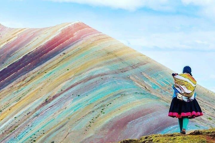
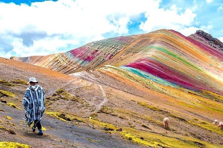
The bus cuts through pre-dawn darkness and then the highlands open like a page of geology: ochre slopes, razor ridges and the banded colors of Palcoyo rising against a cold blue sky. Early light paints the slopes and spits wind that seems to push you uphill; you step out at nearly 4,900 meters where breath comes measured and the panorama rewards the effort.
Verified experiences and guided adventures in the surrounding area.
Operated by Chullos Travel Peru · Cusco, Cusco Region
The bus cuts through pre-dawn darkness and then the highlands open like a page of geology: ochre slopes, razor ridges and the banded colors of Palcoyo rising against a cold blue sky. Early light paints the slopes and spits wind that seems to push you uphill; you step out at nearly 4,900 meters where breath comes measured and the panorama rewards the effort.
Palcoyo sits on the eastern flank of the Andes near the sacred Ausangate massif. Its color bands are not painted rock but sedimentary layers altered by mineral deposits and weathering; local Quechua communities have trodden these altiplanos for centuries and still manage grazing and seasonal paths. The town of Cusipata and small Andean bridges you pass reflect colonial and pre-Colonial travel routes that linked pasture to market.
Expect a short, steep walk once you reach the parking area—photo stops at a colonial bridge and an Inca-style stone crossing are part of the route. Weather changes fast: strong sun one minute, wind and fine cold the next. Operators often include breakfast, lunch, walking sticks and oxygen assistance; the full loop from Cusco is a long day, roughly 13 hours including driving time.
Practical guide: acclimatize in Cusco (48–72 hours if possible), pace yourself on the ascent, and carry layers, water and sunscreen. Start early to avoid afternoon clouds and to capture the best light on Palcoyo’s stripes. Keep gauge on pace rather than distance—the thin air makes short sections feel steep. Leave no trace: stick to established paths and respect grazing areas and local communities.
Expect a full day: pickups around 4:00 a.m., roughly 5–6 hours round-trip driving and 1–2 hours on-site, with an overall tour time near 12–14 hours.
Yes—Palcoyo is around 4,900 m. Acclimatize in Cusco for 1–2 days, move slowly, hydrate, and use supplied oxygen if needed.
Typical inclusions are hotel pickup/drop-off in Cusco center, breakfast, lunch, walking sticks, oxygen assistance, guide and transport; confirm details with the operator.
Local communities sometimes charge a small entry fee at the parking/access point; operators often handle payments—confirm at booking.
Chullos Travel Peru operates guided outdoor trips and adventures with an emphasis on safety, stewardship, and memorable experiences.
The bus cuts through pre-dawn darkness and then the highlands open like a page of geology: ochre slopes, razor ridges and the banded colors of Palcoyo rising against a cold blue sky. Early light paints the slopes and spits wind that seems to push you uphill; you step out at nearly 4,900 meters where breath comes measured and the panorama rewards the effort.
The bus cuts through pre-dawn darkness and then the highlands open like a page of geology: ochre slopes, razor ridges and the banded colors of Palcoyo rising against a cold blue sky. Early light paints the slopes and spits wind that seems to push you uphill; you step out at nearly 4,900 meters where breath comes measured and the panorama rewards the effort.
Palcoyo sits on the eastern flank of the Andes near the sacred Ausangate massif. Its color bands are not painted rock but sedimentary layers altered by mineral deposits and weathering; local Quechua communities have trodden these altiplanos for centuries and still manage grazing and seasonal paths. The town of Cusipata and small Andean bridges you pass reflect colonial and pre-Colonial travel routes that linked pasture to market.
Expect a short, steep walk once you reach the parking area—photo stops at a colonial bridge and an Inca-style stone crossing are part of the route. Weather changes fast: strong sun one minute, wind and fine cold the next. Operators often include breakfast, lunch, walking sticks and oxygen assistance; the full loop from Cusco is a long day, roughly 13 hours including driving time.
Practical guide: acclimatize in Cusco (48–72 hours if possible), pace yourself on the ascent, and carry layers, water and sunscreen. Start early to avoid afternoon clouds and to capture the best light on Palcoyo’s stripes. Keep gauge on pace rather than distance—the thin air makes short sections feel steep. Leave no trace: stick to established paths and respect grazing areas and local communities.