THE ADVENTURE COLLECTIVE® · Independent discovery and booking for outdoor travel

Follow the wartime paths to Pu To Co Peak and stand where commanders once watched the Muong Thanh Valley. This one-day trek blends 1,700m summit views with guided history and NW Vietnam’s rugged geology.
Follow the wartime paths to Pu To Co Peak and stand where commanders once watched the Muong Thanh Valley. This one-day trek blends 1,700m summit views with guided history and NW Vietnam’s rugged geology.
Morning fog lifts off the Muong Thanh Valley as your jeep drops you at the trailhead and the ridge seems to wake around you. Footsteps on damp leaf litter, the steady breath of the forest, and a guide’s quiet stories of the 1954 campaign give the climb a double weight—physical and historical.
Verified experiences and guided adventures in the surrounding area.
Operated by Authentic Travel in Vietnam · Dien Bien Phu, Dien Bien Province
Morning fog lifts off the Muong Thanh Valley as your jeep drops you at the trailhead and the ridge seems to wake around you. Footsteps on damp leaf litter, the steady breath of the forest, and a guide’s quiet stories of the 1954 campaign give the climb a double weight—physical and historical.
The trail follows sections of the wartime routes used during the Battle of Dien Bien Phu; granite outcrops and weathered limestone ridgelines frame the ascent. Geologically, the northwest of Vietnam is a mix of folded sedimentary rocks and eroded hilltops that create steep, sometimes narrow trails and broad viewpoints. Culturally, the area is home to Thai and Hmong communities—look for terraced fields and simple mountain villages where local food and hospitality trace back generations.
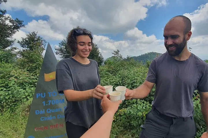
From Pu To Co’s summit at about 1,700 meters the Muong Thanh basin spreads below; commanders once used this vantage to study lines and supply routes, and today the same sweep helps you place the battlefield in landscape terms.
Practical guidance: expect roughly three hours of steady uphill walking to the peak, rooted trails with occasional rock and mud, and rapid weather shifts—carry a rain shell and plenty of water. The operator includes breakfast, lunch, bottled water, and a bilingual guide; transport is by jeep or motorbike from Dien Bien Phu. Respect historical sites—don’t remove artifacts—and follow your guide on steeper sections. Early starts avoid midday heat and improve visibility for the valley views, while sturdy footwear and basic trekking poles make the return easier.
The route is classified moderate: about three hours uphill on mixed dirt and rock, with gradual to steep sections; suitable for most active travelers.
At roughly 1,700 meters altitude effects are generally mild; those with cardiorespiratory conditions should consult a doctor—guides monitor pace and rest breaks.
No special permits are typically required for this guided day trek; entry to Muong Phang historical sites may be included by the operator.
Tours include English and Vietnamese-speaking guides; ask about other languages when booking if needed.
Authentic Travel in Vietnam operates guided outdoor trips and adventures with an emphasis on safety, stewardship, and memorable experiences.
Morning fog lifts off the Muong Thanh Valley as your jeep drops you at the trailhead and the ridge seems to wake around you. Footsteps on damp leaf litter, the steady breath of the forest, and a guide’s quiet stories of the 1954 campaign give the climb a double weight—physical and historical.
Morning fog lifts off the Muong Thanh Valley as your jeep drops you at the trailhead and the ridge seems to wake around you. Footsteps on damp leaf litter, the steady breath of the forest, and a guide’s quiet stories of the 1954 campaign give the climb a double weight—physical and historical.
The trail follows sections of the wartime routes used during the Battle of Dien Bien Phu; granite outcrops and weathered limestone ridgelines frame the ascent. Geologically, the northwest of Vietnam is a mix of folded sedimentary rocks and eroded hilltops that create steep, sometimes narrow trails and broad viewpoints. Culturally, the area is home to Thai and Hmong communities—look for terraced fields and simple mountain villages where local food and hospitality trace back generations.
From Pu To Co’s summit at about 1,700 meters the Muong Thanh basin spreads below; commanders once used this vantage to study lines and supply routes, and today the same sweep helps you place the battlefield in landscape terms.
Practical guidance: expect roughly three hours of steady uphill walking to the peak, rooted trails with occasional rock and mud, and rapid weather shifts—carry a rain shell and plenty of water. The operator includes breakfast, lunch, bottled water, and a bilingual guide; transport is by jeep or motorbike from Dien Bien Phu. Respect historical sites—don’t remove artifacts—and follow your guide on steeper sections. Early starts avoid midday heat and improve visibility for the valley views, while sturdy footwear and basic trekking poles make the return easier.