THE ADVENTURE COLLECTIVE® · Independent discovery and booking for outdoor travel

Leave the highway and let the canyon set the pace. This 3-hour guided off-road tour from Globe, Arizona, threads ridgelines, abandoned mines and river canyons of the Tonto National Forest — ideal for photographers and anyone who wants to see a rarely visited slice of the Sonoran high country.
Leave the highway and let the canyon set the pace. This 3-hour guided off-road tour from Globe, Arizona, threads ridgelines, abandoned mines and river canyons of the Tonto National Forest — ideal for photographers and anyone who wants to see a rarely visited slice of the Sonoran high country.
The engine settles into a steady grunt and the scrub around you leans into motion — juniper needles flick like static, ocotillo stems bend as if taking a breath. The road narrows and the world opens: sheer cliffs step away from the trail, an arroyo flashes silver where Ash Creek threads toward the Salt River, and the canyon drops into a bowl you can feel more than see. This is the Tonto National Forest’s wilder side, a landscape that resists easy access and rewards the curious with cliffs, old mine timbers and long views that make the horizon look like the last line of a good map.
Verified experiences and guided adventures in the surrounding area.
Operated by Arizona Off-Road Adventures · Claypool, Arizona
The engine settles into a steady grunt and the scrub around you leans into motion — juniper needles flick like static, ocotillo stems bend as if taking a breath. The road narrows and the world opens: sheer cliffs step away from the trail, an arroyo flashes silver where Ash Creek threads toward the Salt River, and the canyon drops into a bowl you can feel more than see. This is the Tonto National Forest’s wilder side, a landscape that resists easy access and rewards the curious with cliffs, old mine timbers and long views that make the horizon look like the last line of a good map.
Geology and human history are written on every slope. The Salt River and its tributaries have cut through volcanic flows and sedimentary beds for millennia, exposing layered rock faces and loose scree that make an off-road vehicle feel like the right way to read the land. In the late 19th and early 20th centuries prospectors built small mining camps; their remnants perch on ridgelines and give you a tangible link to the region’s copper-and-claim past. Ranching followed the miners, and you’ll travel across a working cattle ranch where cows graze like punctuation marks across the high plains.
Culturally the corridor sits at a crossroads: Native American history threads nearby, early miners left names carved into maps, and locals still treat the canyon as a place to drive out and clear the head. Guides on this tour double as interpreters — they point out desert plants, call out eagle sightings, and explain how forest-service roads keep access sustainable.
Practicalities are straightforward. Meet at the parking area off US-60 (mile marker 283) for a short safety briefing before the 3-hour loop. Terrain is mostly dirt and small rock with short stretches of rougher wash and ridgeline exposures; expect open-air seating and the occasional jostle. The operator supplies bottled water and soda; bring a sun hat, closed-toe shoes, and a light jacket for canyon wind. Photo-wise, the best light is an hour after sunrise or late afternoon when shadows give the cliffs texture.
Safety notes are part of the start: this trip isn’t strenuous on foot but isn’t recommended for travelers with serious back, heart, or pregnancy concerns. Wildlife encounters are common — raptors, lizards, and the occasional grazing cattle — so keep movement measured and cameras ready. If you want the quietest experience, pick a shoulder-season morning: the desert blooms lightly in spring and the air holds that sharp clarity you only get at altitude.
By the time you roll back onto Highway 60, the canyon has done what it does best: it’s reframed how you measure distance — not by miles, but by views, by old foundations, and by the small revelations the Sonoran high country hands out when you’re willing to leave the pavement.
Meet at the parking lot off US Highway 60 at mile marker 283; guides will be standing by with off-road vehicles.
The tour is family-friendly and suitable for most ages, but it’s not recommended for travelers with serious back, heart, or pregnancy concerns due to vehicle movement.
Bottled water and soda are provided; the tour includes guide-led driving, stops at overlooks and historical sites, and safety briefing.
There are brief stops for photos and short walks near viewpoints and old mine structures; extended hikes are not part of the standard 3-hour itinerary.
Wear closed-toe shoes, sun protection, and layers. Comfortable clothing that can handle dust and wind is best.
Facilities are limited; plan to use restrooms in Globe or at the meeting lot before departure and at designated stops if available.
Arizona Off-Road Adventures operates guided outdoor trips and adventures with an emphasis on safety, stewardship, and memorable experiences.
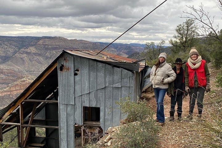


The engine settles into a steady grunt and the scrub around you leans into motion — juniper needles flick like static, ocotillo stems bend as if taking a breath. The road narrows and the world opens: sheer cliffs step away from the trail, an arroyo flashes silver where Ash Creek threads toward the Salt River, and the canyon drops into a bowl you can feel more than see. This is the Tonto National Forest’s wilder side, a landscape that resists easy access and rewards the curious with cliffs, old mine timbers and long views that make the horizon look like the last line of a good map.
The engine settles into a steady grunt and the scrub around you leans into motion — juniper needles flick like static, ocotillo stems bend as if taking a breath. The road narrows and the world opens: sheer cliffs step away from the trail, an arroyo flashes silver where Ash Creek threads toward the Salt River, and the canyon drops into a bowl you can feel more than see. This is the Tonto National Forest’s wilder side, a landscape that resists easy access and rewards the curious with cliffs, old mine timbers and long views that make the horizon look like the last line of a good map.
Geology and human history are written on every slope. The Salt River and its tributaries have cut through volcanic flows and sedimentary beds for millennia, exposing layered rock faces and loose scree that make an off-road vehicle feel like the right way to read the land. In the late 19th and early 20th centuries prospectors built small mining camps; their remnants perch on ridgelines and give you a tangible link to the region’s copper-and-claim past. Ranching followed the miners, and you’ll travel across a working cattle ranch where cows graze like punctuation marks across the high plains.
Culturally the corridor sits at a crossroads: Native American history threads nearby, early miners left names carved into maps, and locals still treat the canyon as a place to drive out and clear the head. Guides on this tour double as interpreters — they point out desert plants, call out eagle sightings, and explain how forest-service roads keep access sustainable.
Practicalities are straightforward. Meet at the parking area off US-60 (mile marker 283) for a short safety briefing before the 3-hour loop. Terrain is mostly dirt and small rock with short stretches of rougher wash and ridgeline exposures; expect open-air seating and the occasional jostle. The operator supplies bottled water and soda; bring a sun hat, closed-toe shoes, and a light jacket for canyon wind. Photo-wise, the best light is an hour after sunrise or late afternoon when shadows give the cliffs texture.
Safety notes are part of the start: this trip isn’t strenuous on foot but isn’t recommended for travelers with serious back, heart, or pregnancy concerns. Wildlife encounters are common — raptors, lizards, and the occasional grazing cattle — so keep movement measured and cameras ready. If you want the quietest experience, pick a shoulder-season morning: the desert blooms lightly in spring and the air holds that sharp clarity you only get at altitude.
By the time you roll back onto Highway 60, the canyon has done what it does best: it’s reframed how you measure distance — not by miles, but by views, by old foundations, and by the small revelations the Sonoran high country hands out when you’re willing to leave the pavement.