THE ADVENTURE COLLECTIVE® · Independent discovery and booking for outdoor travel

Walk through San Pancho’s seaside streets and headlands with a local guide, get professional photos and videos of your visit, and optionally add drone footage for aerial views of Bahía de Banderas. This 2–4 hour private tour blends local culture, coastal scenery, and practical storytelling.
Walk through San Pancho’s seaside streets and headlands with a local guide, get professional photos and videos of your visit, and optionally add drone footage for aerial views of Bahía de Banderas. This 2–4 hour private tour blends local culture, coastal scenery, and practical storytelling.
You step off a shaded street into a breeze coming off the bay; palms lean and the ocean pushes sound toward the sand. This San Pancho tour moves at a human pace—walking lanes, a beachside promenade, a few short climbs to lookouts—while guides point out alleys, murals and the best angles for photos.
Verified experiences and guided adventures in the surrounding area.
Operated by Tour Drone MX · San Pancho (San Francisco), Nayarit
You step off a shaded street into a breeze coming off the bay; palms lean and the ocean pushes sound toward the sand. This San Pancho tour moves at a human pace—walking lanes, a beachside promenade, a few short climbs to lookouts—while guides point out alleys, murals and the best angles for photos.
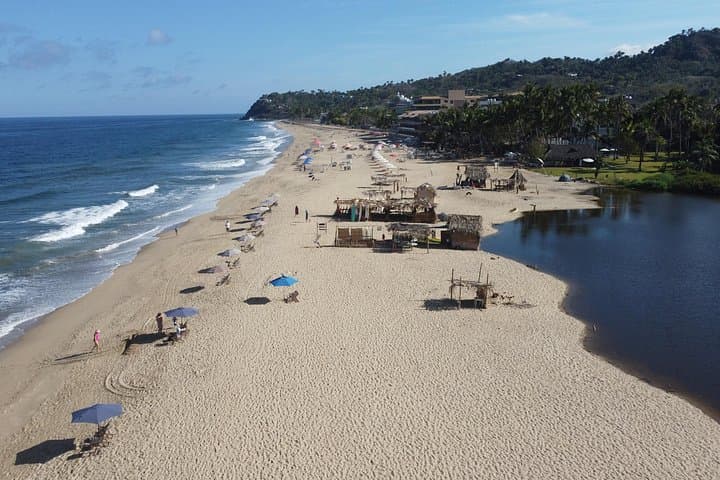
San Pancho (San Francisco, Nayarit) began as a fishing and farming village on the northern edge of Bahía de Banderas. The coastline here is shaped by volcanic geology and coastal sediment, producing rocky headlands, sandy coves, and a shallow estuary that attracts shorebirds. Local culture blends small-town surf life, artisanal markets, and community conservation efforts, including sea-turtle protection and neighborhood art projects.
The experience mixes on-foot exploration with a multimedia finish: professional photos and video are included, and drone footage is available as an optional upgrade for sweeping aerial perspectives over the bay. Expect 2–4 hours of guided walking with private transport available and light snacks provided.
Practical notes: wear grippy shoes for uneven sidewalks and headlands, bring sun protection and a refillable water bottle, and charge your phone if you want copies of images immediately. The route is accessible to most fitness levels but includes short uphill sections and sandy beach walking. Book in advance for mornings or late afternoons to catch softer light for photos and to avoid midday heat. For photographers, the tour pairs local storytelling with reliably photogenic coastal views—an efficient way to collect memories and a few great aerial shots of Bahía de Banderas.
The standard tour includes professional photos and video from the ground; drone footage is available as an optional paid upgrade where local regulations and conditions allow.
Expect mostly short, guided walks between viewpoints and market areas—generally easy walking with occasional sandy or uneven sections over the 2–4 hour timeframe.
Tours welcome families and service animals; check with the operator about age recommendations and safety for small children near cliff edges or rocky headlands.
Full refunds are available if you cancel at least 24 hours before the scheduled departure; bad-weather cancellations may also apply.
Tour Drone MX operates guided outdoor trips and adventures with an emphasis on safety, stewardship, and memorable experiences.


You step off a shaded street into a breeze coming off the bay; palms lean and the ocean pushes sound toward the sand. This San Pancho tour moves at a human pace—walking lanes, a beachside promenade, a few short climbs to lookouts—while guides point out alleys, murals and the best angles for photos.
You step off a shaded street into a breeze coming off the bay; palms lean and the ocean pushes sound toward the sand. This San Pancho tour moves at a human pace—walking lanes, a beachside promenade, a few short climbs to lookouts—while guides point out alleys, murals and the best angles for photos.
San Pancho (San Francisco, Nayarit) began as a fishing and farming village on the northern edge of Bahía de Banderas. The coastline here is shaped by volcanic geology and coastal sediment, producing rocky headlands, sandy coves, and a shallow estuary that attracts shorebirds. Local culture blends small-town surf life, artisanal markets, and community conservation efforts, including sea-turtle protection and neighborhood art projects.
The experience mixes on-foot exploration with a multimedia finish: professional photos and video are included, and drone footage is available as an optional upgrade for sweeping aerial perspectives over the bay. Expect 2–4 hours of guided walking with private transport available and light snacks provided.
Practical notes: wear grippy shoes for uneven sidewalks and headlands, bring sun protection and a refillable water bottle, and charge your phone if you want copies of images immediately. The route is accessible to most fitness levels but includes short uphill sections and sandy beach walking. Book in advance for mornings or late afternoons to catch softer light for photos and to avoid midday heat. For photographers, the tour pairs local storytelling with reliably photogenic coastal views—an efficient way to collect memories and a few great aerial shots of Bahía de Banderas.