THE ADVENTURE COLLECTIVE® · Independent discovery and booking for outdoor travel

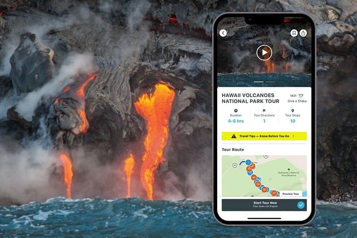
Explore Hawai‘i’s volcanic heart on your own schedule with a GPS-driven audio tour that guides you to craters, lava fields, petroglyphs, and coastal arches. Download the route, drive Crater Rim Drive, and mix short walks with interpretive narration at your pace.
Explore Hawai‘i’s volcanic heart on your own schedule with a GPS-driven audio tour that guides you to craters, lava fields, petroglyphs, and coastal arches. Download the route, drive Crater Rim Drive, and mix short walks with interpretive narration at your pace.
You start the drive before dawn, headlights cutting through mist as the caldera holds its low, steady breath. Steam vents plume like sentries and the road threads past jagged pāhoehoe and ʻaʻā, each turn revealing a different face of the island's formative heat.
Verified experiences and guided adventures in the surrounding area.
Operated by Shaka Guide Apps · Volcano, Hawaii
You start the drive before dawn, headlights cutting through mist as the caldera holds its low, steady breath. Steam vents plume like sentries and the road threads past jagged pāhoehoe and ʻaʻā, each turn revealing a different face of the island's formative heat.
This self-guided audio drive walks you through the park’s layered story: Pele's legends woven into modern geology, the volcanic plumbing of Kīlauea and Mauna Loa, and the archaeological footprint of petroglyph fields left by Hawaiʻi’s early residents. The landscape is recent in geological terms—lava flows from centuries and decades ago still read as new scars—and older forested kipukas stand as islands of soil and life amid black rock.
Cultural context is part of the route: stops highlight sacred places, historic observatories, and how island communities have long respected and adapted to eruptions. For nature lovers, the tour points to native bird habitat pockets and coastal features like the Holei Sea Arch where waves test the old lava tubes.
Practical notes: the tour is GPS-driven and works offline—download before you arrive. Expect a mix of paved driving and short walks: Devastation Trail is an easy 1-mile loop on hardened ash; Kīlauea Iki is a 4-mile crater hike with 400 ft elevation change if you choose to stretch your legs. Bring water, sun protection, and a wind jacket; volcanic gas can spike near vents and visibility changes fast. The guide is modular—pause, stop, and linger where the park lures you to stay.
No—download the Shaka Guide tour and offline maps while on Wi‑Fi; GPS triggers narration without cellular data.
Yes—Hawaiʻi Volcanoes National Park charges an entrance fee; check the National Park Service site for current rates and vehicle passes.
Active lava visibility is intermittent and depends on current eruptive activity and safety closures; the app will note viewpoints if visible and safe.
Many overlooks and some trails (like parts of Crater Rim Drive and Devastation Trail) are accessible, but check specific site notes for surface and gradient details.
Shaka Guide Apps operates guided outdoor trips and adventures with an emphasis on safety, stewardship, and memorable experiences.


You start the drive before dawn, headlights cutting through mist as the caldera holds its low, steady breath. Steam vents plume like sentries and the road threads past jagged pāhoehoe and ʻaʻā, each turn revealing a different face of the island's formative heat.
You start the drive before dawn, headlights cutting through mist as the caldera holds its low, steady breath. Steam vents plume like sentries and the road threads past jagged pāhoehoe and ʻaʻā, each turn revealing a different face of the island's formative heat.
This self-guided audio drive walks you through the park’s layered story: Pele's legends woven into modern geology, the volcanic plumbing of Kīlauea and Mauna Loa, and the archaeological footprint of petroglyph fields left by Hawaiʻi’s early residents. The landscape is recent in geological terms—lava flows from centuries and decades ago still read as new scars—and older forested kipukas stand as islands of soil and life amid black rock.
Cultural context is part of the route: stops highlight sacred places, historic observatories, and how island communities have long respected and adapted to eruptions. For nature lovers, the tour points to native bird habitat pockets and coastal features like the Holei Sea Arch where waves test the old lava tubes.
Practical notes: the tour is GPS-driven and works offline—download before you arrive. Expect a mix of paved driving and short walks: Devastation Trail is an easy 1-mile loop on hardened ash; Kīlauea Iki is a 4-mile crater hike with 400 ft elevation change if you choose to stretch your legs. Bring water, sun protection, and a wind jacket; volcanic gas can spike near vents and visibility changes fast. The guide is modular—pause, stop, and linger where the park lures you to stay.