THE ADVENTURE COLLECTIVE® · Independent discovery and booking for outdoor travel

Drive a 40-mile ribbon of Jersey’s coast and countryside with a downloadable-ready web plan that maps beaches, castles, WWII sites and Neolithic dolmens. Use curated itineraries for 3–14 days and follow pre-pinned Google Map routes to explore at your pace.
Drive a 40-mile ribbon of Jersey’s coast and countryside with a downloadable-ready web plan that maps beaches, castles, WWII sites and Neolithic dolmens. Use curated itineraries for 3–14 days and follow pre-pinned Google Map routes to explore at your pace.
The road opens like a map beneath a low, Atlantic sky: narrow lanes edged with hedgerows, chalky headlands dropping to surf, and villages where stone cottages lean into the wind. This self-guided plan lays out a 40-mile point-to-point route across Jersey’s southern and western shores, stitching beaches, castles, wartime sites and prehistoric dolmens into a run of days you can set to your own pace.
Verified experiences and guided adventures in the surrounding area.
Operated by Uncover Britain Road Trips · Saint Helier, Jersey
The road opens like a map beneath a low, Atlantic sky: narrow lanes edged with hedgerows, chalky headlands dropping to surf, and villages where stone cottages lean into the wind. This self-guided plan lays out a 40-mile point-to-point route across Jersey’s southern and western shores, stitching beaches, castles, wartime sites and prehistoric dolmens into a run of days you can set to your own pace.
Geology here is blunt and visible — granite outcrops, raised beaches and tidal causeways that expose the island’s relationship with the sea. History is close at hand: Mont Orgueil’s medieval ramparts watch the France coastline, and the War Tunnels recall the island’s World War II occupation. Local culture is equally tactile: fish markets in the mornings, vineyards producing small-batch cider and spirits, and tidal traditions that still govern causeway crossings.
Practically, the guide bundles sample itineraries for 3–14 days, suggested parking, and pre-populated Google Map pins to guide point-to-point drives and short walks. Expect beach stops at St. Brelade’s Bay, a tide-windowed walk to Corbière Lighthouse, surf-facing St. Ouen’s Bay, and quieter ruins and dolmens inland.
Plan around tides, bring layers for sudden coastal wind, and allow time for short walks from parking to viewpoints — many highlights require a 10–30 minute stroll. The guide is web-based with 12 months’ access; it’s not downloadable but works well on phones with offline map caching. For travelers who prefer structure without a guidebook’s rigidity, this is a practical, scenic outline for experiencing Jersey on your own terms.
The guide outlines roughly 40 miles of highlights designed for 3–14 days; compressing it into a day is possible by car but you’ll miss walks, museum time and tide-dependent sites.
The plan is web-based and not an app download; you can cache Google Map areas and use the site on mobile browsers while offline.
No — roads are standard two-lane lanes with occasional narrow stretches; normal driving experience suffices, though watch for cyclists and agricultural vehicles.
Yes, if you check local tide times and follow marked crossing windows for causeways like Corbière; the guide flags tide-sensitive stops.
Uncover Britain Road Trips operates guided outdoor trips and adventures with an emphasis on safety, stewardship, and memorable experiences.
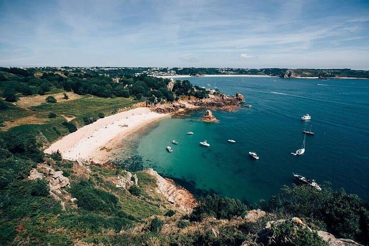



The road opens like a map beneath a low, Atlantic sky: narrow lanes edged with hedgerows, chalky headlands dropping to surf, and villages where stone cottages lean into the wind. This self-guided plan lays out a 40-mile point-to-point route across Jersey’s southern and western shores, stitching beaches, castles, wartime sites and prehistoric dolmens into a run of days you can set to your own pace.
The road opens like a map beneath a low, Atlantic sky: narrow lanes edged with hedgerows, chalky headlands dropping to surf, and villages where stone cottages lean into the wind. This self-guided plan lays out a 40-mile point-to-point route across Jersey’s southern and western shores, stitching beaches, castles, wartime sites and prehistoric dolmens into a run of days you can set to your own pace.
Geology here is blunt and visible — granite outcrops, raised beaches and tidal causeways that expose the island’s relationship with the sea. History is close at hand: Mont Orgueil’s medieval ramparts watch the France coastline, and the War Tunnels recall the island’s World War II occupation. Local culture is equally tactile: fish markets in the mornings, vineyards producing small-batch cider and spirits, and tidal traditions that still govern causeway crossings.
Practically, the guide bundles sample itineraries for 3–14 days, suggested parking, and pre-populated Google Map pins to guide point-to-point drives and short walks. Expect beach stops at St. Brelade’s Bay, a tide-windowed walk to Corbière Lighthouse, surf-facing St. Ouen’s Bay, and quieter ruins and dolmens inland.
Plan around tides, bring layers for sudden coastal wind, and allow time for short walks from parking to viewpoints — many highlights require a 10–30 minute stroll. The guide is web-based with 12 months’ access; it’s not downloadable but works well on phones with offline map caching. For travelers who prefer structure without a guidebook’s rigidity, this is a practical, scenic outline for experiencing Jersey on your own terms.