THE ADVENTURE COLLECTIVE® · Independent discovery and booking for outdoor travel

Launch from Cerro Santa Elena and glide in tandem over Valle del Cauca’s rivers, groves, and haciendas. This two-hour outing from Cali pairs easy access with dramatic aerial views and local pilot expertise.
Launch from Cerro Santa Elena and glide in tandem over Valle del Cauca’s rivers, groves, and haciendas. This two-hour outing from Cali pairs easy access with dramatic aerial views and local pilot expertise.
You feel the wind first — a steady, warm push that dares you to step to the edge. From the Cerro Santa Elena launch near Piedechinche the valley opens beneath you: patchwork fields, winding rivers, groves of guayacan trees and the long shadow of the Andes. The pilot counts down, the wing fills, and the world smooths out; currents take over and the city of Cali becomes a bright coin in the distance.
Verified experiences and guided adventures in the surrounding area.
Operated by La sucursal del cielo · Cali, Valle del Cauca
You feel the wind first — a steady, warm push that dares you to step to the edge. From the Cerro Santa Elena launch near Piedechinche the valley opens beneath you: patchwork fields, winding rivers, groves of guayacan trees and the long shadow of the Andes. The pilot counts down, the wing fills, and the world smooths out; currents take over and the city of Cali becomes a bright coin in the distance.
The takeoff zone sits on volcanic foothills carved by erosion and centuries of agriculture; haciendas like El Paraíso shaped the human story here and created the clearings pilots rely on. Local pilots read thermal seams the way farmers read weather — patterns earned through seasons of flying. You’ll cross cañaduzales and small river valleys, often escorted by thermals that push you along and the occasional vulture circling like a practiced guide.
Practical guidance: the advertised experience runs about two hours door-to-door with roughly 15–30 minutes airborne on a typical tandem. Pickup in Cali is standard; bring a valid passport and the name details required at booking. Wear sturdy closed-toe shoes, sun-protective layers, and secure any loose cameras — the ride is calm but moments of lift can be sudden.
Best times are the drier months and late afternoon when thermal activity is steady and colors deepen. Listen closely to your pilot during briefing and landing; they’ll guide posture and braking for a smooth touchdown.
This is low-impact, high-view adventure: short on effort, big on perspective. Expect friendly local crews, quick briefings, and panoramas that put the scale of the valley into sharp focus.
Actual airtime typically ranges from 15 to 30 minutes depending on thermal conditions; the full experience including pickup and briefing is about two hours.
Yes — flights are done in tandem with certified pilots who control the wing; passengers need only follow instructions during takeoff and landing.
This operator lists the activity as suitable for all fitness levels, but you should disclose medical conditions and check age limits with the provider at booking.
Flights may be rescheduled or canceled for unsafe wind or rain; check the provider’s cancellation policy and ask about alternate times if the weather is marginal.
La sucursal del cielo operates guided outdoor trips and adventures with an emphasis on safety, stewardship, and memorable experiences.
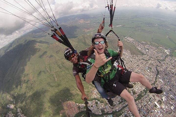

You feel the wind first — a steady, warm push that dares you to step to the edge. From the Cerro Santa Elena launch near Piedechinche the valley opens beneath you: patchwork fields, winding rivers, groves of guayacan trees and the long shadow of the Andes. The pilot counts down, the wing fills, and the world smooths out; currents take over and the city of Cali becomes a bright coin in the distance.
You feel the wind first — a steady, warm push that dares you to step to the edge. From the Cerro Santa Elena launch near Piedechinche the valley opens beneath you: patchwork fields, winding rivers, groves of guayacan trees and the long shadow of the Andes. The pilot counts down, the wing fills, and the world smooths out; currents take over and the city of Cali becomes a bright coin in the distance.
The takeoff zone sits on volcanic foothills carved by erosion and centuries of agriculture; haciendas like El Paraíso shaped the human story here and created the clearings pilots rely on. Local pilots read thermal seams the way farmers read weather — patterns earned through seasons of flying. You’ll cross cañaduzales and small river valleys, often escorted by thermals that push you along and the occasional vulture circling like a practiced guide.
Practical guidance: the advertised experience runs about two hours door-to-door with roughly 15–30 minutes airborne on a typical tandem. Pickup in Cali is standard; bring a valid passport and the name details required at booking. Wear sturdy closed-toe shoes, sun-protective layers, and secure any loose cameras — the ride is calm but moments of lift can be sudden.
Best times are the drier months and late afternoon when thermal activity is steady and colors deepen. Listen closely to your pilot during briefing and landing; they’ll guide posture and braking for a smooth touchdown.
This is low-impact, high-view adventure: short on effort, big on perspective. Expect friendly local crews, quick briefings, and panoramas that put the scale of the valley into sharp focus.