Trekking the Mullerthal Trail: A Practical Journey Through Luxembourg’s Rocky Heartland
The Mullerthal Trail in Luxembourg reveals a rugged world of sandstone cliffs and quiet forests, perfect for those seeking both stunning landscapes and a trail with practical challenges. This guide prepares you for navigating its routes with clear tips and vivid descriptions to make your hike rewarding and manageable.
Trail Tips
Start Early for Cooler, Quiet Trails
Begin your hike at sunrise or early morning to avoid crowds and take advantage of cool temperatures that ease the physical challenge.
Wear Durable, Grippy Footwear
The trail terrain varies from smooth paths to slippery rocks; sturdy hiking boots with solid traction reduce injury risk and improve stability.
Bring Adequate Water and Snacks
Limited supply points along the trail mean carrying sufficient hydration and energy food to maintain stamina during longer stretches.
Use Trail Markings and Maps
While the Mullerthal Trail is well marked, supplement with maps or a GPS device to avoid disorientation in dense woodland sections.
Trekking the Mullerthal Trail: A Practical Journey Through Luxembourg’s Rocky Heartland
Hiking the Mullerthal Trail offers a unique blend of raw geology and peaceful scenery in Luxembourg’s eastern region. This trail, spanning approximately 112 kilometers, is divided into three main routes, each offering varied terrain and distinct rock formations shaped by centuries of natural sculpting. Expect elevation gains ranging from moderate incline to challenging climbs around 400 meters, which reward hikers with views where sandstone cliffs seem to stand watch over quiet forest floors and bubbling creeks. The rocks here dare you to trace their rough surfaces, while shaded paths provide a welcome canopy for cool relief.
Start early to beat the crowds and take advantage of softer morning light that brings textures and colors alive. The well-marked trail crosses mossy boulders, narrow ravines, and small caves, making footing diverse and requiring sturdy footwear with good grip. Along the way, the forests appear alive, trees bending slightly as if whispering to the wind, inviting measured respect for their enduring presence. The serene Mur river threads beneath ancient bridges, its current pushing forward as you advance.
For practical planning: pack enough water to stay hydrated—there are limited refilling spots—and dress in layers, as weather shifts under the forest canopy can be sudden. If you aim to complete all three routes, consider spacing your hike over multiple days and lodging in nearby Echternach, where cozy guesthouses provide a welcomed rest.
Though the trail offers adventure, it demands awareness and preparation. Routes can be slippery after rain, and sudden elevation changes test your endurance. Trail markers are reliable but bring a detailed map or GPS device. For those with a keen eye, abundant fern patches and occasional woodpecker rhythms add natural soundtrack to your trek.
Ultimately, hiking the Mullerthal Trail is engaging with a landscape fiercely itself—neither tamed nor static—offering an active, hands-on experience with nature’s craftsmanship. It’s a journey not just to witness the stunning rock formations and serene landscapes but to walk alongside forces that have shaped this wild pocket of Luxembourg over millennia.
Recommended Gear
Hiking Boots with Good Traction
Necessary to handle rocky, sometimes slippery terrain and provide ankle support.
null specific
Layered Clothing
Allows adaptation to temperature fluctuations from shaded forests to exposed ridge tops.
all specific
Water Bottle or Hydration Pack
Hydration is crucial due to limited refill options on the trail.
all specific
Trail Map or GPS Device
Helps prevent disorientation in dense woodland areas despite well-marked routes.
null specific
Frequently Asked Questions
How many routes make up the Mullerthal Trail?
The Mullerthal Trail is divided into three main routes—Route 1, Route 2, and Route 3—each with unique landscapes and lengths, combining for approximately 112 kilometers in total.
Is the Mullerthal Trail suitable for beginners?
Segments of the trail are accessible to beginners with reasonable fitness levels, but some areas feature steep climbs and uneven terrain, making portions moderately challenging.
Are there accommodations near the trail?
Yes, the nearby town of Echternach offers a variety of lodging options including guesthouses, small hotels, and camping sites ideal for multi-day hiking trips.
When is the best time of day to hike for photography?
Early morning and late afternoon provide soft, directional light that highlights the textures of the sandstone formations and forest foliage.
Can I hike the trail year-round?
While the trail is open year-round, seasonal weather impacts conditions. Snow and ice in winter require extra gear, and heavy rainfall in spring can make paths muddy.
Are pets allowed on the Mullerthal Trail?
Dogs are permitted but must be kept on a leash due to local regulations and consideration for wildlife and other hikers.
Local Insights
Hidden Gems
- "Schiessentümpel Waterfall – a lesser-known cascade perfect for a tranquil break"
- "Hidden rock caves near Hohllay formations offering cool retreat and exploration"
- "The quiet ridge above Echternach that presents sweeping views away from main paths"
Wildlife
- "Red squirrels darting through trees"
- "Various woodpeckers whose tapping provides an audible sense of the forest"
- "Occasional sightings of foxes and deer in more secluded areas"
History
"The Mullerthal region has long been a passageway connecting medieval towns, evidenced by ancient bridges and ruins along the trail reflecting European trade and pilgrimage routes."
Nearby Landmarks
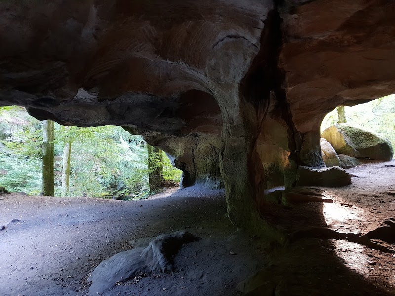
Cavern Wonders at Hohllay Cave, Luxembourg
Just outside the charming town of Berdorf in Luxembourg, the Hohllay Cave offers an enticing natural escape. This unique geological wonder,...
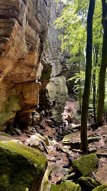
Rock Climbing Adventures in Berdorf
Rock Climbing Area Berdorf, located in the scenic region of Luxembourg, offers a unique and thrilling experience for climbing enthusiasts. Renowned...
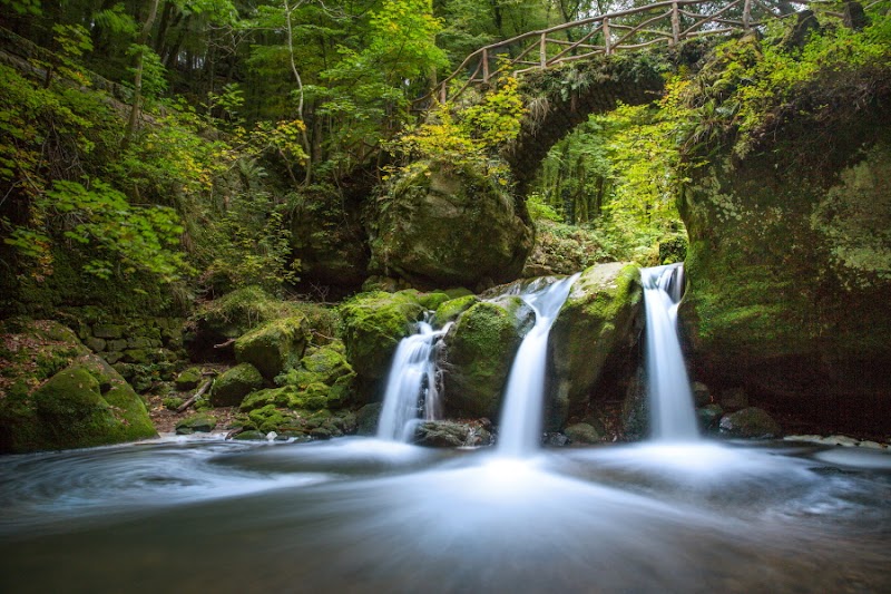
Waterfall Wonder at Schiessentümpel
Schiessentümpel Waterfall: A Must-Visit in Mullerthal
Tucked away in the charming Mullerthal region of Luxembourg, Schiessentümpel Waterfall offers...
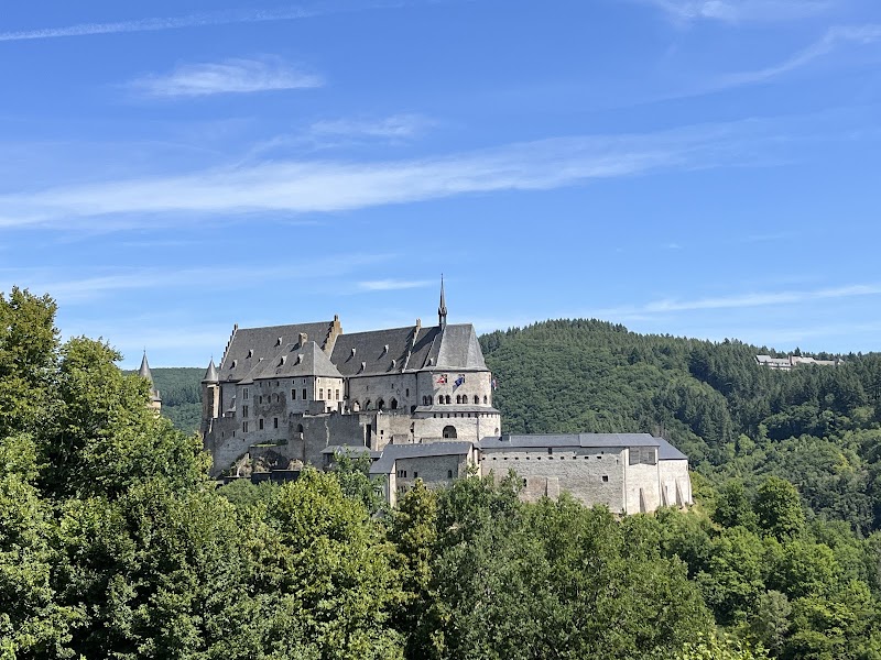
Discover Vianden Castle: A Medieval Marvel
Vianden Castle, perched prominently in the enchanting hills of Vianden, Luxembourg, is a striking reminder of medieval grandeur and architectural...
Tranquil Waters & Natural Beauty: Haff Réimech
Haff Réimech, located near Schengen in the Luxembourg region, is a picturesque sanctuary for nature enthusiasts. This area stands out as a serene...