
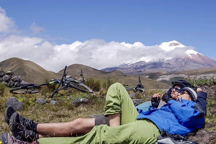
What the day feels like
You push off from the park gate with a small herd of wind-bent grasses hustling in the same direction. The first kilometer is easy — a gravel service road that lets your legs settle into the thin, sharp air. Then the landscape changes as if someone has inverted the map: black, glassy lava fields give way to ochre pumice, and the slopes of Cotopaxi looms ahead, a blunt white tooth capped with cloud. On a clear day the volcano dominates the horizon, an enormous metronome that times your breaths.
This is not summit-day mountaineering; it is an immersion in high Andean geology and culture at bicycling speed. The Private Cotopaxi Biking Adventure is a 6–8 hour loop through the southeast flank of Cotopaxi National Park, typically covering roughly 25–35 kilometers with 600–900 meters of cumulative climbing depending on the chosen route. Trails alternate between hard-packed dirt, pumice fields, and short sections of singletrack braided through ichu grass. The ride is an honest, sometimes humbling, high-altitude day: thin air makes everything feel steeper, and the views arrive in sudden, wide-open chapters.
Geology here reads like a stratified autobiography. Cotopaxi is part of the Eastern Cordillera of the Ecuadorian Andes, a volcano that has reshaped the valley floors with repeated eruptions. Much of the terrain you ride is parched volcanic tephra: dusty, low-friction rock that sings under tires and sometimes obliges a cautious dismount. Rumiñahui, the neighboring summit, keeps an older, more weathered profile — rounded ridgelines and talus slopes that speak to a longer history of glaciation and erosion. Lava flows, ash deposits, and the scars of past pyroclastic events create the region's signature contrast: sterile black fields interrupted by sudden pockets of grazing pasture and rustic haciendas.
The cultural beat is as noticeable as the wind. Riders will pass small Andean farms where horses and cattle graze at 3,500–4,200 meters, and locals still tend to plots of potatoes and quinoa carved out of volcanic soil. Traditional agriculture hums quietly — shaggy llamas and stray dogs cross paths with mountain bikers, and a practiced gait from local riders provides an unspoken lesson in how to manage steep, loose descents. Guides are often from nearby communities; their knowledge of altitude, weather shifts, and volcanic terrain is essential and illuminates a side of the Andes you won't find in guidebooks.
Why bike here? The combination of high-altitude challenge, raw scenery, and geological variety produces a day that feels both remote and accessible from Quito. In contrast to the steady approach and single-minded toil of a summit bid, a bike tour offers a moving tapestry of the park: sudden ridgeline overlooks, a close-up of an old lava tube, a herd of wild horses framed by the volcano's snow cone.
Practical reality sits close to the romantic frame. The ride is best for those accustomed to steady effort at altitude; oxygen is thinner and recovery slower. The day typically begins at the park entrance around 3,200–3,800 meters, with the trail climbing to viewpoints around 4,200–4,500 meters. Even on a non-technical route, the combination of loose pumice and occasional headwind means good traction tires and careful line choice matter. Guides will provide helmets and basic safety kit, and most tours include warm layers, snacks, and water — but you should come prepared: hydration systems, CO2 cartridges or a pump, and a compact multi-tool are essential. The tour requires a minimum of two passengers and is offered as a private experience, so itineraries can be tailored to skill level and weather.
Timing is everything. Mornings are typically clearer: a stable high-pressure window in the dry season lets you ride in sun with views of the snowline. Afternoon convective weather brings wind and clouds that can quickly wrap the peaks in gray, dropping temperature and visibility. The dry season (June–September) is prime for confident, dust-free trails; the wet months soften the pumice, making descents slower and muddier.
Safety and etiquette are straightforward. Keep to established tracks to protect fragile high-altitude grasses and small tundra ecosystems. Respect livestock and local land — many trails cross private pasture. If you feel dizzy, nauseous, or intensely fatigued, descend and seek medical attention; altitude affects people unevenly and conservatively descending is the best strategy.
At day's end you return to lowland warmth, likely with pica — that appetite made of cold air and effort. Nearby towns like Machachi or Latacunga have modest restaurants where you can find hearty locro de papa (potato soup), roasted cuy in some places, or a plate of hornado with mote. Share stories with your guide: why a line across a slope matters, where the park has reshaped local grazing patterns, which ridgelines are best for condor sightings. The Cotopaxi bike day is not just about the kilometers you ride — it is a lesson in moving lightly at altitude, reading a volcanic landscape, and letting nature's blunt beauty set the pace.
For travelers, the appeal is clear: it’s a day that feels properly wild but is logistically simple from Quito, a place where geology, culture, and exertion meet. Come fit, come curious, and leave ready to plan a return — maybe to climb, maybe to explore lesser volcanic flanks by foot. And pack layers: Cotopaxi will remind you that at high altitude even the sun can be an unreliable ally.
Trail wisdom
Small choices, better day.
Acclimatize first
Spend 24–48 hours in Quito or another mid-elevation town before riding to reduce altitude symptoms.
Tire choice matters
Use wider, knobbed tires (2.1 in or larger) to handle loose pumice and hard-packed volcanic dirt.
Dress in layers
Sun, wind, and sudden cloud cover are common — pack a windproof shell and insulating mid-layer.
Hydrate early and often
Bring at least 2–3 liters of water and sip regularly; altitude increases dehydration risk.
Local knowledge
Read the place, not just the route.
Watch for native species including Wild horses roaming park pastures, Andean condor sightings in thermic afternoons.
Keep an eye out for wildlife during the transition between areas and habitats. Respect distance guidelines.
The park is fragile high-altitude tundra; stay on trails, pack out waste, and support local guides who practice responsible tourism.
Follow the guide's instructions on size limits, ethical handling, and leave-no-trace practices.
Rumiñahui viewpoint for panoramic photos of Cotopaxi and the valleys below. Small hacienda tea-rooms near Machachi serving local soups and empanadas
Locally recommended viewpoints and quiet spots known best to local operators.
Cotopaxi National Park was established in 1975 to protect the high Andean páramo and the volcano's unique landscapes; Cotopaxi itself reaches 5,897 meters.
Maritime roots and regional tradition shape the waterways and working coasts.
Seasonal guide
Four versions of the same landscape.
Spring
Best forfewer crowds · wildflower pockets · cool temperatures
Challengesincreasing afternoon showers · muddy low-elevation trails
March–May leans toward the wet season with occasional clear days; expect some rain and softer trail sections.
Summer
Best fordry trails · stable weather · long daylight
Challengesstrong sun and UV exposure · cold mornings
June–August is the dry season and the best window for consistent blue skies and fast riding.
Fall
Best fortransitional light · fewer tour groups · good visibility
Challengesvariable weather · possible early rains
September–November can be mixed: excellent days interspersed with early wet-season storms.
Winter
Best fordramatic clouds · lusher lowlands · cool temperatures
Challengesfrequent rain · reduced visibility and muddy sections
December–February are wetter months; be prepared for shorter clear windows and slippery terrain.
Operator details
What the booking data adds.
Included
- ✓Private transportation
- ✓Lunch
- ✓Use of bicycle
- ✓Gear: Trek X caliber, 29 inches wheels, rock shock suspension, hydraulic brakes, bontrager helmets.
- ✓Certified AJ expert English-speaking Adventure Trip Leader
Not included
- —Travel Insurance (Mandatory)
- —Tips
Good to know
- ✓Specialized infant seats are available
- ✓Not recommended for travelers with spinal injuries
- ✓Not recommended for pregnant travelers
- ✓Not recommended for travelers with poor cardiovascular health
- ✓Travelers should have at least a moderate level of physical fitness
Pack with intention
What to bring.
Good to know
Common questions.
Expect around 25–35 kilometers total with roughly 600–900 meters of cumulative ascent depending on the route chosen by your guide.
Plan the edges
The details that make the day easier.
Cotopaxi reaches 5,897 meters and is among the world's highest active volcanoes; Cotopaxi National Park was established in 1975 to protect its unique páramo ecosystem.
After the ride head to Latacunga or Machachi for hearty Andean dishes like locro de papa or hornado. Local eateries serve fresh soups and roasted meats paired with mote; small microbreweries in Latacunga offer a welcome cold beer after a long, high-day.
- Closest airport
- Mariscal Sucre International Airport (Quito). Driving time from Quito: ~1.5–2 hours to park entrance. Cell service: intermittent in the park; expect coverage near park buildings. Permits
- fees
- park entry fee required; tour minimum of two passengers.
Stay on designated trails to protect fragile páramo vegetation; pack out all trash, avoid disturbing wildlife, and hire local guides to support community-based conservation.
Explore by topic
Follow the threads.
Keep exploring
Make the story part of the trip.
 Related story
Less than two hours from Nairobi, Kereita Forest pairs hands-on canopy adventure with quiet montane trails and a sobering colonial history—perfect for families, teams, and curious travelers seeking a full-day pulse of nature.
Set out from Bass Harbor for a private, customizable day on Blue Hill Bay — lighthouses, puffins, seals, and the chance to feel Acadia from the water. Small groups, local captains, unforgettable views.
In four hours you can move from shaded canyon ferns to wind-scoured coastal ridgelines, guided by someone who knows where the light—and the hidden views—live. This private half-day hike on the Monterey Peninsula or Big Sur is compact, curated, and perfect for travelers who want depth without a multiday commitment.