Mastering Weather and Trail Access on the Paiute Trail: A Practical Guide
The Paiute Trail offers a compelling mix of alpine beauty and desert endurance, but its weather and trail access demand careful planning. This guide breaks down what you need to know to navigate the trail’s shifting conditions and varied terrain with confidence.
Start Early to Beat Heat and Afternoon Storms
Morning temperatures are cooler and safer, especially in exposed low deserts; afternoon thunderstorms can develop quickly in higher elevations.
Carry Water Filtration Devices
Water sources are limited and seasonal, so a reliable filtration system is necessary for safe hydration on longer stretches.
Monitor Road and Trailhead Access Closures
Access roads often close due to snow or mudslides. Check local ranger station updates before your trip to avoid unexpected detours.
Wear Supportive and Durable Footwear
Trails range from sandy sections to rocky switchbacks; proper boots with ankle support reduce injury risk and improve stability.
Mastering Weather and Trail Access on the Paiute Trail: A Practical Guide

Three Night Cabin Rental
2 Bedroom Cabin $447 | 3 nights | All ages welcome
Escape to Utah’s scenic landscapes with a three-night private cabin stay combined with thrilling UTV rentals. Explore rugged trails and unwind in comfort at Rose Ranch Resort—your perfect outdoor getaway awaits!
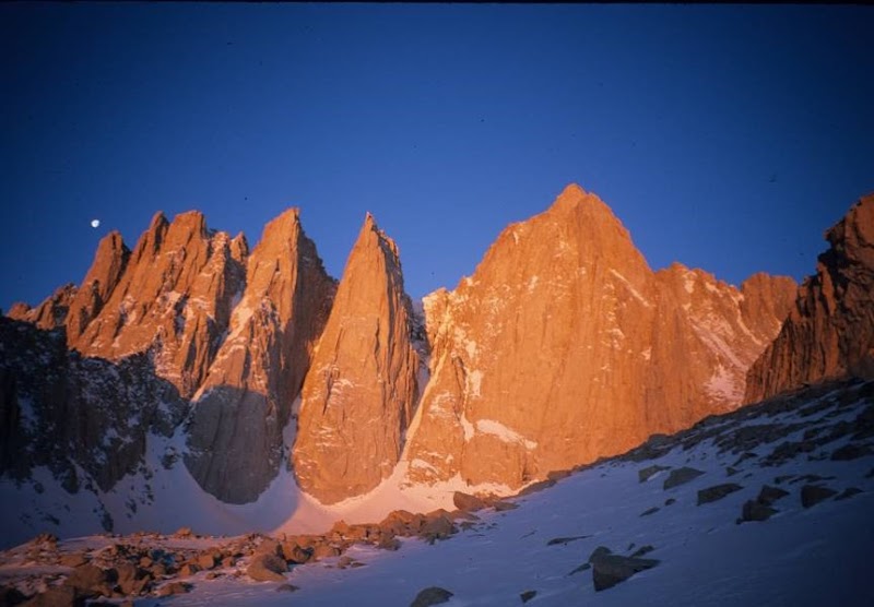
The Paiute Trail stretches across the varied landscape of California’s Eastern Sierra, challenging hikers with its elevation swings, weather shifts, and remote terrain. Measuring roughly 110 miles end-to-end, this trail weaves through high desert flats and alpine ridges, demanding thoughtful planning around weather and trail access to ensure a safe, rewarding experience.
From spring thaw to autumn’s first frost, the Paiute Trail reveals a dynamic personality. Winters clamp down with snow that seals off large sections, while summer afternoons bring sudden thunderstorms that roll over the ridges, daring you to outpace their rush. Elevations vary from 5,000 feet in valleys to over 11,000 near summit passes, so temperatures swing dramatically, day to night.
Trailheads vary in accessibility, often dictated by seasonal road closures and local weather’s grip. The south and northern trailheads, near Bishop and Bridgeport respectively, provide the most reliable access during late spring through early fall. Keep in mind that heavy snow or lingering mudslides can delay openings well into June.
Terrain underfoot transitions constantly, from sandy washes and sagebrush plains to rocky switchbacks threaded through pine forests. Some stretches demand sturdy boots with strong grip and ankle support. Trail markers are present but can become sparse in exposed areas, so carrying a detailed GPS or map is essential.
Weather is the true companion on the Paiute. Early morning coolness can shift to blazing sun by midday in dry stretches, while alpine zones remain cool and crisp. Always prepare for afternoon winds that carry the scent of pine and dust, pushing against your progress.
Hydration is critical since natural water sources are intermittent and often seasonal. Carry filtration gear and know the locations of verified springs before heading out. Timing your hikes to start early can help you avoid midday heat and afternoon storms that surge up canyon walls.
Planning access means respecting the forces the trail embodies. Situations can change rapidly—roads close to prevent damage or due to unpredictable weather, campsites may fill quickly in peak months, and the trail’s toughness will test your physical and mental resources.
Know your limits and pack accordingly. Weather layers that wick moisture, breathable fabrics, sun protection, and rain gear form an essential ensemble. Emergency communication devices gain extra importance in this remote stretch, where cellular service is spotty.
Ultimately, the Paiute Trail asks for attention and respect while offering sweeping views of the Sierra’s raw edges, fragrant forests, and the stark solitude of the high desert. Planning your trip with careful attention to weather and access elevates your experience and ensures that adventure stays firmly in the realm of the exhilarating rather than the hazardous.
Nearby Trips
All Adventures
Boat Charters
Water Activities
Adventures near Bishop
Discover the unique and memorable adventures that make Bishop special.
Frequently Asked Questions
When is the Paiute Trail officially open for through-hikes?
While not formally regulated, the trail is generally accessible from late June through early October, depending on snowpack and road conditions. Ranger stations provide updates on road openings to crucial trailheads.
Are there reliable water sources along the Paiute Trail?
Water sources are intermittent and largely seasonal, often found in springs or creeks at higher elevations. Carrying a filtration device is mandatory as untreated water can contain harmful bacteria.
What kind of wildlife might I encounter along the trail?
Expect to see mule deer, black bears, various birds like Steller’s jays, and reptiles basking on sunny rocks. At dawn or dusk, curious foxes sometimes appear near campsites.
Are there any cultural or historical points of interest on the trail?
The Paiute Trail passes through lands historically used by the Northern Paiute people. Watch for petroglyphs near specific sites and remnants of old mining camps dating to the late 19th century.
How challenging is navigation on the Paiute Trail?
Trail markings can be sparse, especially in open desert stretches. Basic proficiency in map and compass use or a reliable GPS device is highly recommended to avoid route confusion.
Is camping allowed along the trail?
Yes, dispersed camping is allowed but restricted in sensitive areas. Use established sites when possible, follow Leave No Trace principles, and check for fire restrictions before starting.
Recommended Gear
Sturdy Hiking Boots
Protects feet and ankles on mixed terrain, including rocky and sandy portions.
Water Filtration System
Ensures safe hydration given limited and seasonal water sources.
Layered Clothing System
Allows adapting to rapid weather changes from hot sun to chill winds.
Weatherproof Rain Jacket
Protects against unexpected rain and afternoon mountain storms.
Local Insights
Hidden Gems
- "Eagle Lake Overlook – offers a rarely visited vantage point of the Sierra peaks."
- "Lost Cabin – an abandoned miner’s cabin accessible via a short detour."
- "Willow Springs Patch – a quieter water source supporting lush riparian vegetation."
Wildlife
- "American pika"
- "Mountain lion (rare but present)"
- "Great horned owl"
- "California quail"
History
"This trail runs through traditional lands once traveled seasonally by the Northern Paiute tribe, linking hunting grounds and water sources. Later, miners and settlers used parts of this route during the California gold rush era."