Navigating Water Conditions for Kayaking and Canoeing in Boundary Waters Canoe Area Wilderness
Paddle the expansive waterways of Boundary Waters Canoe Area Wilderness with confidence by preparing for its dynamic water conditions. This guide equips you with the practical knowledge needed to navigate shifting currents, changing winds, and hidden obstacles for a safer, more enjoyable kayaking or canoeing adventure.
Check Local Weather and Wind Patterns
Local forecasts often capture sudden weather shifts better than general reports—plan your route based on predicted wind speeds and directions for safer paddling.
Dress in Layers with Quick-Drying Fabrics
Temperatures can change rapidly on the water; layering with moisture-wicking materials keeps you comfortable and prevents chills after exposure to spray or wind.
Scout Portages Ahead of Time
Portage routes may be muddy or rocky, especially after rain; knowing their condition helps prevent injury and speeds transitions between lakes.
Master Basic Self-Rescue Skills
Currents and waves can flip your canoe or kayak; practicing how to re-enter your craft or swim safely is crucial for wilderness safety.
Navigating Water Conditions for Kayaking and Canoeing in Boundary Waters Canoe Area Wilderness

One Hour Kayak or Canoe Rental
Starting at $33.99 • Select your start date!
Discover the thrill of paddling with a one-hour kayak or canoe rental on Hilton Head Island. Perfect for all ages, these rentals deliver quick access to scenic waterways teeming with wildlife. Read on to find out what makes this adventure a local favorite.
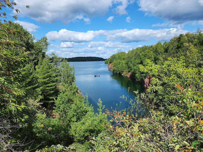
The Boundary Waters Canoe Area Wilderness (BWCAW) in northern Minnesota stands as a testing ground for paddlers eager to engage with water that is alive and unpredictable. Here, lakes spread like open arms, while rivers and streams weave with currents that challenge your craft and compel respect. Preparing for the water conditions means anticipating their moods—from calm glassy surfaces to brisk winds stirring waves that push your kayak or canoe forward or sideways.
Understanding BWCAW’s hydrology is key before you dip your paddle. The area is renowned for its interconnected waterways, spanning roughly 1 million acres, offering routes ranging from short loops under 10 miles to extended trips over 50 miles. Elevation gain is minimal, but the water can be mentally and physically demanding due to the variable weather and hidden obstacles like submerged rocks or sudden shallow areas.
Spring snowmelt swells streams and rivers, sending currents with renewed vigor that dare you to match pace. Summer’s warmth encourages calm waters but also calls for vigilance against swift wind gusts skimming across open lakes. Fall brings cooler, sharper winds and dropping water levels revealing more hazards below, while winter freezes the waterways, transforming the experience entirely.
To prepare, start with reliable weather forecasts, ideally from local sources. A wind of 10-15 mph can trim your speed by half or more, dictating route choices that favor sheltered lakes or narrower channels where the water breathes more gently. Plan your daily mileage factoring in these shifts; an easily paddled 8-mile day in calm conditions might stretch to 12 or more hours under opposing wind and waves.
Gear is your shield: a buoyant, stable craft matched to your skill level, a personal flotation device designed for swiftwater, and clothing layered for sudden temperature swings. Carry a waterproof map or GPS, and practice self-rescue techniques, since the wilderness waters do not forgive lapses.
Engage with the wilderness as an equal contender—feel the wind press against your back, the water’s resistance pull at your paddle, and the steady rhythm needed to keep on course. Respect the power of the currents and anticipate waves that can roll unexpectedly. Portages between lakes test more than your strength; they ask for patience and preparation, as gear must be securely stowed and transitioned with care.
Arriving at a campsite after hours on water, the reward is tangible: reflections ripple from your kayak’s wake, shorelines steep in spruce and birch seem to lean in quietly, and the sense of accomplishment is as deep as the waters. But the real preparation is in knowing you’ve equipped yourself to meet these waters as a partner, alert and ready, able to adapt and push forward with steady hands.
In essence, kayaking and canoeing within BWCAW is a dance with water conditions that command respect and understanding. Prepare your body, gear, and mindset, and the wilderness will offer its challenges and quiet triumphs equally.
Nearby Trips
All Adventures
Boat Charters
Water Activities
Adventures near Ely
Discover the unique and memorable adventures that make Ely special.
Frequently Asked Questions
How do changing water levels affect paddling routes in the BWCAW?
Water levels fluctuate notably with seasons and precipitation, exposing or submerging portage paths, altering current strength, and changing navigability. Spring's high water enables easier travel over some portages but faster currents, while fall may require longer or alternate routes as some waterways shrink.
What wildlife should paddlers watch for on the water?
Expect to encounter loons sliding haunting calls across the lakes, otters darting near shores, and sometimes bald eagles soaring overhead. Be cautious of snapping turtles and avoid disturbing nesting birds along quiet coves.
Are motorized boats allowed in the Boundary Waters?
No, the BWCAW is designated as a motor-free wilderness, preserving its quiet, natural state. This restriction amplifies the connection between paddlers and unbroken nature.
What measures protect the environment here?
Visitors follow Leave No Trace principles, using established campsites and limiting campfires. The use of biodegradable soaps and packing out all trash helps maintain water purity and forest health.
Where are lesser-known viewpoints accessible by canoe?
Try Gunflint Lake’s northeast shore, where rocky bluffs open to sweeping water scenes without frequent visitors. The Eagle Mountain portage area also offers quiet spots with stark, reflective views.
When is the best time to avoid mosquitoes during paddling trips?
Late July into August typically sees a natural decline in mosquito activity due to heat and dryness, providing more comfortable paddling days. Early spring and early summer bring the highest insect presence, so plan accordingly.
Recommended Gear
Personal Flotation Device (PFD)
A fit, Coast Guard-approved PFD is non-negotiable for safety, providing flotation and added visibility.
Waterproof Map or GPS Device
Navigating BWCA’s complex waterways demands precise navigation aids to avoid getting lost.
Layered Clothing System
Multiple layers enable quick adjustment to temperature swings and help manage moisture to maintain comfort.
Dry Bags
Protect gear, food, and electronics from water; securing everything tightly is vital to avoid damage.
Local Insights
Hidden Gems
- "The Devil's Cascade on the Kawishiwi River, a series of small rapids favored by intermediate paddlers seeking a bit of adrenaline."
- "Little Fall Lake for quiet fishing spots away from main canoe routes."
Wildlife
- "Common loons ensuring iconic calls across the pristine waters."
- "Beaver activity shaping waterways, creating dams and lodges seen from paddling routes."
- "Occasional sightings of black bears near shoreline campsites."
History
"The Boundary Waters hold cultural significance for the Ojibwe people, sustaining a legacy of travel and resource gathering that continues through respectful wilderness use."