Navigating Freedom's Backcountry Bike Routes: Safety Essentials and Photo Hotspots
Freedom, NH's backcountry bike routes blend rugged challenge with vivid natural beauty, offering riders both adrenaline and contemplative moments. Learn how to safely navigate these unmarked trails while capturing memorable photographic views.
Wear Protective Gear
Always wear a helmet and gloves to protect against unexpected falls or branch strikes on narrow trails.
Carry Navigation Tools
GPS devices or offline maps are vital due to limited signage and cell reception in deep forest areas.
Hydrate Frequently
Bring at least 2 liters of water—routes can take 2-4 hours, and the physical effort increases dehydration risk.
Plan Ride Timing
Start mid-morning to ensure ample daylight, avoiding dusk when visibility drops and temperatures fall.
Navigating Freedom's Backcountry Bike Routes: Safety Essentials and Photo Hotspots

Half Day Bicycle Tour/Lesson
Starting from $170 | 2-3 Hours | Up to 8 People | Ride the Back Roads
Discover the scenic beauty of Freedom, NH, on a private half-day bicycle tour with Outdoor Escapes. Perfect for all skill levels, this experience blends guided cycling, local history, and outdoor fun. Keep reading to learn what makes this adventure a must-try!
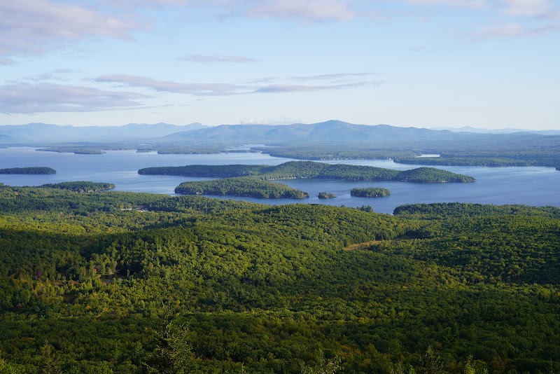
Freedom, NH, offers backcountry bike routes where rugged terrain meets the quiet pulse of nature fiercely itself. Expect 8-12 miles of mixed forest trails and gravel roads, with elevation gains of 800 to 1,200 feet. The paths carve through thick stands of spruce and pine, while brooks dart alongside, daring riders to keep pace. The routes demand respect; roots and rocks catch tires unexpectedly, and sudden climbs command measured effort.
Photographers will find their frames filled with sweeping hilltop views and filtered sunlight through dense canopy. The golden light of early morning sharpens textures—the bark’s roughness, dew on ferns—while late afternoon shadows sculpt the land’s contours. Stop beside the Swift River’s tumbling currents that push forward relentlessly, casting reflections that challenge the stillness.
Safety is non-negotiable here. Helmets and gloves guard against the uneven ground and low branches. Hydration packs and layered clothing respond to quick shifts in weather—Freedom’s backcountry is swift and unpredictable. Maps or GPS devices are essential; marked trails aren’t guaranteed, and phone signals dip in wooded hollows. Timing your ride from mid-morning to mid-afternoon maximizes daylight and visibility, reducing risks as fatigue sets in.
This isn’t a route for sprinting—it’s a dialogue with land that resists fast conquest. Take time to plan, respect conditions, and savor the isolated beauty. The adventure lies not just in distance, but in answering the call of a landscape that’s fiercely itself, challenging you both in skill and patience.
Nearby Trips
All Adventures
Boat Charters
Water Activities
Adventures near Laconia
Discover the unique and memorable adventures that make Laconia special.
Frequently Asked Questions
Are the backcountry routes in Freedom marked clearly?
No, many trails are minimally marked, so using GPS or offline maps is strongly recommended. Relying solely on signage can lead to disorientation.
What wildlife might I encounter on these routes?
Expect to see white-tailed deer, various birds including woodpeckers and warblers, and occasionally black bears. Early morning or late afternoon are prime times for wildlife activity.
Is it necessary to have mountain biking experience to ride here?
Yes. The trails involve technical sections with roots, rocks, and elevation changes that require confident bike handling skills and physical preparation.
Can I camp along these backcountry bike routes?
Primitive camping is possible but limited. Be sure to observe Leave No Trace principles, and check local regulations regarding camping permissions.
Are there any water refill points on the trails?
Natural streams are present, but water should be filtered or purified before drinking. Carry adequate water as refill stations are scarce or nonexistent.
What historical or cultural sites are nearby?
Freedom’s logging history is evident in the old stone leantos and remnants of forest railway ties. These features hint at a past where the land was harnessed more industrially, contrasting with today’s wilderness use.
Recommended Gear
Helmet
Protects the head from impacts caused by falls or low-hanging branches.
Hydration Pack
Allows easy access to water, crucial for staying hydrated on demanding routes.
Layered Clothing
Adjust layers easily to manage changing temperatures and unpredictable weather.
GPS Device or Offline Map
Navigation tools are critical given limited trail markers and poor cell signal.
Local Insights
Hidden Gems
- "Lookout Point above Swift River—offers expansive views often missed by casual riders"
- "The old logging camp ruins near Mill Pond for a glimpse into Freedom’s past"
- "Quiet meadows along Brooks Road rich with wildflowers in late spring"
Wildlife
- "Black bear"
- "White-tailed deer"
- "Red fox"
- "Pileated woodpecker"
History
"Freedom carries deep footprints of New Hampshire's logging industry from the late 1800s, visible in scattered relics like stone foundations and old railroad tie remains that peek from under leaf litter. These traces connect riders to a time when the forest was a working landscape."