Navigating Virginia Beach: Choosing the Right Trail Map and Accessories for Paved Trail Biking
Virginia Beach’s paved trails offer a seamless blend of coastal charm and practical adventure for bikers of all levels. With the right trail map and gear, riders can confidently navigate scenic routes lined by forest whispers and bay breezes, making each ride both exhilarating and well-prepared.
Choose Between Digital and Printed Maps
Digital maps provide real-time tracking and reroutes, while printed maps offer reliable coverage without worrying about battery life.
Hydrate Frequently
Virginia Beach’s coastal air can mask dehydration. Carry a water bottle in an accessible cage and refill at designated stations along the route.
Plan Your Ride Timing
Ride in early mornings or late afternoons to avoid midday heat and crowds, and enjoy the changing energy of the trails.
Bring a Multi-Tool Kit
Unexpected mechanical issues happen. A compact multi-tool can keep minor repairs manageable without derailing your adventure.
Navigating Virginia Beach: Choosing the Right Trail Map and Accessories for Paved Trail Biking

Comfort Bike - All Day Rentals
Starting at $55 | 8 Hour Rentals | All Sizes
Discover the scenic paved trails of Truckee with Bike Truckee’s all-day comfort bike rentals. Perfect for relaxing rides, these bikes provide a smooth, accessible way to experience California’s Sierra Nevada landscape at your own pace.
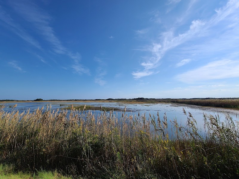
Virginia Beach offers an inviting network of paved trails where city meets nature with a rhythm that’s both steady and refreshing. Selecting the right trail map is your first step to seize control of the experience, whether you're rolling along the Chesapeake Bay or cruising through forest-lined stretches. The Virginia Beach Trail System spans roughly 26 miles of smooth pavement, weaving through coastal parks and waterways that dare the breeze to keep pace with your wheels. Elevation changes are modest, rarely topping 50 feet, but the gentle inclines invite you to engage with the landscape rather than simply move past it.
Choosing your trail map means balancing detail with ease of use. Digital maps like TrailLink or AllTrails offer real-time updates and GPS tracking, vital for riders who crave flexibility and on-the-go reroutes. Yet, a printed map from the Virginia Beach Parks & Recreation office provides trustworthy coverage without battery reliance, an essential for longer tours. Both styles highlight key points: rest stops, water fountains, and nearby attractions like the Mount Trashmore Park or the boardwalk’s sea spray flirtations.
Accessories reinforce your readiness on these trails. A handlebar phone mount doubles as a GPS holder, keeping maps in your line of sight without disruptive stops. Hydration is critical amid the salty air and intermittent sunlit stretches, making a water bottle cage non-negotiable. Also, a compact multi-tool tucked into a saddle bag can resolve minor mechanical glitches, keeping you rolling past any sudden hiccups.
Timing matters. Early mornings reveal the trails waking up — the gulls squabble over open spaces, and currents in the nearby lagoons push forward with quiet insistence. Late afternoons offer cooler temperatures and shadowed canopy relief, though sunsets draw more traffic, calling for cautious riding. Footwear, simple yet effective, combines comfort with grip; breathable cycling gloves, meanwhile, protect your handshake with the handlebars, a tactile link to the trail’s pulse.
Virginia Beach’s paved trails are an invitation to explore a fiercely alive environment that respects your pace. The key is preparation through the right maps and gear, enabling an adventure that blends curiosity, movement, and practical confidence.
Nearby Trips
All Adventures
Boat Charters
Water Activities
Adventures near Virginia Beach
Discover the unique and memorable adventures that make Virginia Beach special.
Frequently Asked Questions
What is the best way to get a reliable trail map for Virginia Beach?
Virginia Beach Parks & Recreation provides printed maps at their office, which cover main trails and amenities reliably. For more flexibility, apps like AllTrails and TrailLink offer GPS-based digital maps with user reviews and real-time location tracking.
Are paved trails in Virginia Beach suitable for beginner bikers?
Yes, the trails are predominantly flat and paved, making them accessible for riders of all skill levels, including beginners and families.
What wildlife might I encounter on these paved trails?
Keep an eye out for great blue herons near waterways, eastern box turtles crossing shaded paths, and occasional deer glimpsed in nearby wooded areas. Early morning rides increase chances for wildlife sightings.
Is it safe to ride the trails at night or dusk?
While some trails are lit near urban edges, many areas lack lighting. Riding at dusk is possible with proper lights and reflective gear, but nighttime rides are generally discouraged for safety reasons.
Are there water refill stations along the trail routes?
Yes, several parks along the trail system, including Mount Trashmore, provide water fountains. Carrying your own water is still advised, especially during the hotter months.
Can I combine this trail biking with visits to cultural or historical sites?
Absolutely. The trails connect to coastal parks with historical markers, including remnants of old plantation sites and the military history embedded around the Chesapeake Bay area.
Recommended Gear
Handlebar Phone Mount
Keeps maps and GPS easily visible while riding, improving navigation without stopping.
Water Bottle in Cage
Provides hydration on the go, crucial for beating the coastal heat and humidity.
Compact Multi-Tool
Essentials for making on-trail bike repairs and adjustments to prevent breakdowns.
Breathable Cycling Gloves
Protect your hands and improve grip during rides, especially when temperatures are mild.
Local Insights
Hidden Gems
- "The secluded overlook near Millennium Trail offers sweeping bay views with fewer visitors."
- "A tree-lined biking spur adjacent to Red Wing Park where the forest seems to lean in, inviting momentary rests."
Wildlife
- "Ospreys nesting near Lynnhaven River"
- "Migratory shorebirds stopping at Back Bay National Wildlife Refuge"
History
"The paved trail corridors follow paths once used by Native American trade routes and later became critical connectors for coastal communities during colonial times. Mount Trashmore Park itself is a unique environmental reclamation site, transforming a landfill into an urban green space."