Tour de Falls: Exploring Cedar Mountain's Cascading Heart
Tour de Falls offers a captivating loop hike in Cedar Mountain, North Carolina, perfect for adventurers seeking waterfalls and forest immersion without intense technical demands. Discover cascading waters, shaded trails, and a moderate workout that rewards you with panoramic views and lively wildlife encounters.
Wear sturdy footwear
The trail includes rocky and root-filled sections that can be slippery, especially near the waterfalls—boots with solid traction are essential.
Start early or late in the day
Avoid the midday heat by hiking during morning or late afternoon hours when temperatures drop and light is ideal for waterfall viewing and photography.
Bring sufficient water
The humid forest environment can make you sweat more than expected; carry at least 2 liters of water to stay hydrated throughout the 5-mile loop.
Use trekking poles for stability
Steeper sections near the falls benefit from extra support—poles help reduce fatigue and improve balance on uneven or slick terrain.
Tour de Falls: Exploring Cedar Mountain's Cascading Heart
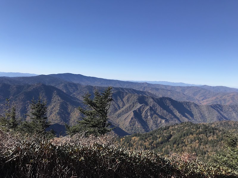
The Tour de Falls trail in Cedar Mountain, North Carolina, invites hikers to engage with nature on intimate terms. Spanning approximately 5 miles round trip, this loop trail weaves through dense hardwood forests, following streams that dare to carve their way down rugged terrain. Elevation gain totals around 700 feet, providing a moderate challenge balanced with moments of quiet reflection among roaring waterfalls and shaded glades.
From the trailhead, the path leads downhill at first, threading through moss-covered stones and over wooden bridges that tremble slightly underfoot. The forest around you feels alive—ancient oaks and maples lean inward, their branches encouraging you forward. Three distinct waterfalls shelter the heart of this hike, each presenting a different face of the water’s persistence: from gentle cascades to roaring plunges.
The terrain fluctuates between rocky segments, soft earth, and occasional roots that demand steady footing. It’s a practical challenge to keep in mind—good boots with solid grip are a must. Hydration packs are equally important; the forest’s humidity can sneak up, sapping energy faster than you expect. Timing your hike for morning or late afternoon helps avoid midday heat and ensures softer light for picture-perfect views.
Wildlife is an active companion here: chipmunks dart between leaves, and the occasional red salamander slips silently under rocks near wet areas. The trail’s soundscape—the water’s steady song, birdsong, and rustling leaves—keeps you grounded in the moment, a reminder that this place is fiercely itself and expects respect.
A highlight for many is the vantage point overlooking High Falls, where water thunders over rocks with force, sending cool mist to greet you. From here, the trail curves upward, rejoining its path with steady but manageable elevation gain.
Prepare for unpredictable weather; sudden showers can make rocks slick and trails muddy. Layers are your friends, and trekking poles can add stability on steeper sections. The effort is rewarded by the chance to stand where water meets stone, feeling the earth’s rhythm pulse through the falls.
Tour de Falls is more than a hike—it’s a compact adventure that offers immersive natural beauty combined with enough challenge to satisfy a broad range of outdoor enthusiasts. Whether you're chasing cascading waters, absorbing forest life, or simply stepping away from urban clatter, this trail delivers clarity and quiet power in each stride.
Nearby Trips
All Adventures
Boat Charters
Water Activities
Adventures near Sylva, North Carolina
Discover the unique and memorable adventures that make Sylva, North Carolina special.
Frequently Asked Questions
How difficult is Tour de Falls for beginners?
While the trail is moderate with some elevation and rocky terrain, beginners with basic fitness and proper footwear can complete it comfortably if they take their time.
Are dogs allowed on the Tour de Falls trail?
Dogs are generally permitted but must be kept on leash to respect local wildlife and other hikers.
Is the trail well-marked and easy to navigate?
The loop is moderately well-marked, but carry a trail map or GPS as some junctions near waterfalls can be confusing, especially after rain.
What wildlife might I encounter on this hike?
Expect to see eastern chipmunks, red salamanders near wet rocks, various songbirds, and possibly white-tailed deer in quieter areas.
Are there good spots for photography along the trail?
Yes. The overlook at High Falls offers sweeping views, and the smaller cascades throughout the loop provide close-up waterfall shots in natural framing.
What environmental practices should I follow on this trail?
Stick to marked paths to prevent erosion, pack out all trash, and avoid disturbing plants or wildlife, especially sensitive salamander habitats near streams.
Recommended Gear
Hiking boots with good traction
Protect your ankles and grip better on rocky, wet surfaces especially around falls.
Hydration pack or water bottles
Stay hydrated to maintain energy in the humid forest environment.
Trekking poles
Optional, but highly recommended for balance on uneven and slippery patches.
Layered clothing
Adjust for temperature swings and be prepared for cooler mornings or sudden weather changes.
Local Insights
Hidden Gems
- "A quiet boulder field near the middle waterfall provides a natural resting spot often missed by casual hikers."
- "An old wooden footbridge near the trail entrance creaks with age and offers a nostalgic photo opportunity."
Wildlife
- "Eastern chipmunks scurrying among leaf litter"
- "Appalachian red salamander lurking near damp rocks"
- "Seasonal sightings of barred owls at dusk"
History
"The area surrounding Tour de Falls has roots in Cherokee lands, with the watercourses historically serving as vital routes and resource sites for indigenous communities."